
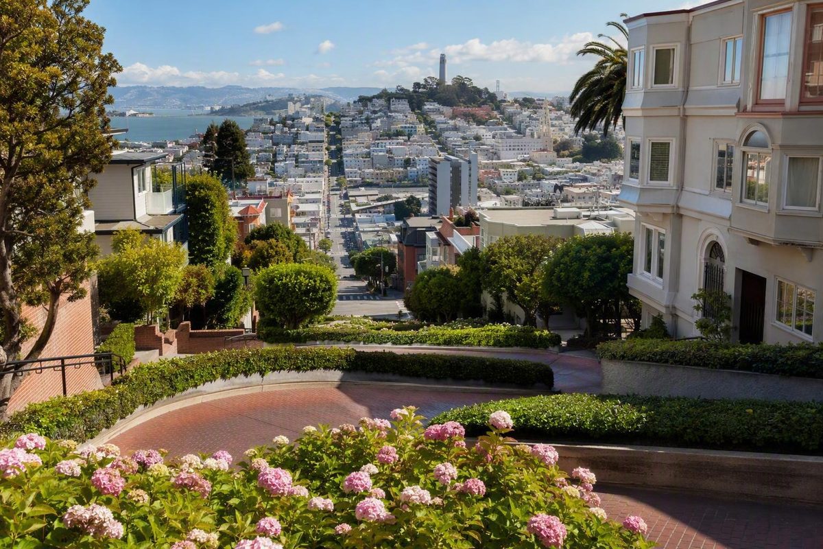
The easiest visit begins with one decision:
- Choose Hyde Street for the upper viewpoint, the downhill walking route, or the one-way vehicle entrance.
- Choose Leavenworth Street for the classic photograph looking uphill through the curves.
- Choose transport based on your comfort with steep pavement, stairs, crowds, and traffic—not merely on which route looks shortest.
Where Lombard Street Is in the USA—and Which Block Visitors Mean
The landmark is in San Francisco’s Russian Hill neighborhood. The famous section occupies one block of Lombard Street between Hyde Street at the top and Leavenworth Street at the bottom.
This distinction matters because Lombard Street itself extends across northern San Francisco from the Presidio toward the Embarcadero. Only the block between Hyde and Leavenworth contains the compact landscaped switchbacks most visitors recognize from photographs. Visit California distinguishes the full street from the one-block landmark.
Lombard Street orientation
- Neighborhood: Russian Hill
- City: San Francisco
- State: California
- Famous block: Hyde Street to Leavenworth Street
- Top and vehicle entrance: Hyde Street
- Bottom and classic uphill view: Leavenworth Street
- Vehicle direction: One way downhill, subject to current controls
For navigation, use intersections rather than relying on a numbered landmark address:
- Enter “Lombard Street and Hyde Street, San Francisco” for the top, upper view, or vehicle entrance.
- Enter “Lombard Street and Leavenworth Street, San Francisco” for the bottom and classic uphill photograph.
- Avoid entering only “Lombard Street,” which may route you to another part of the much longer road.
- Treat numbered attraction pins as approximate because map services and visitor guides do not all use the same address.
Hyde is the more useful starting point for a one-direction pedestrian visit because it allows you to assess the slope and, if comfortable, descend rather than climb. Leavenworth is the better choice when the photograph from below is the priority or when you want to avoid the stairway.
The phrase “Lombard Street USA” does not ordinarily refer to a collection of similarly named streets around the country. In travel searches, it points to this San Francisco landmark. Use the Apple Maps listing for location context.
What You Will Actually See on the Crooked Block
The block contains eight closely spaced turns, a red-brick roadway, planted spaces between the curves, homes on both sides, and public stairways beside the vehicle route. Vehicles travel one way downhill from Hyde toward Leavenworth, while pedestrians use the side paths rather than the brick lane. San Francisco Travel summarizes the block’s layout and visitor access.
From Leavenworth, the turns appear as a compressed zigzag climbing between landscaping and residences. From Hyde, the complete pattern is less visible, but the elevated position can provide broader views across the city and toward the bay when fog and weather permit.
The curved roadway measures approximately 600 feet along its turns. That is a short distance on a map, but the steep approaches, side stairs, crowds, and repeated photo stops can make the visit feel more demanding. The Lombard Street overview reports the roadway’s approximate length.
This is not a closed attraction with a separate visitor campus. It is a functioning residential street. Cars may be entering garages, residents may need their steps and entrances, and pedestrians may be moving in both directions.
Allow approximately 30 to 60 minutes at the block itself for the two endpoint views, photographs, and a careful descent if you choose to use the stairs. That estimate excludes cable-car waits, parking searches, vehicle queues, and travel from another neighborhood. The Cornell Hotel visitor guide gives the same general planning range.
An endpoint-only visit can be shorter. If you want only the familiar uphill view, go to Leavenworth, photograph the block from a public pedestrian area, and leave without climbing. If you begin at Hyde and descend, use the fuller planning window.
How to Reach the Top or Bottom Without Adding the Wrong Hill
The most convenient arrival method depends on your desired endpoint and tolerance for climbing. In San Francisco, a route that looks short in standard map view can still involve a substantial change in elevation.
Powell–Hyde cable car: best aligned with the top
The Powell–Hyde cable car stops at Hyde and Lombard, beside the upper end of the crooked block. It does not travel through the eight switchbacks.
This is a convenient alignment for visitors who want to start at the top and potentially continue downhill. It does not establish a step-free journey: cable-car boarding conditions and the steep environment around the endpoint must be considered separately.
Service, fares, boarding procedures, and accessibility conditions can change. Check current operator information before traveling, especially if a missed connection or inaccessible boarding point would disrupt your plan.
Powell–Mason cable car: useful, but not at the crooked block
The Powell–Mason cable car reaches Lombard Street at Columbus Avenue, several blocks from the famous section. The remaining approach moves toward Russian Hill and can involve significant climbing.
San Francisco Travel identifies both the Powell–Hyde stop near the top and the Powell–Mason stop at Lombard and Columbus. It also describes approaches from nearby districts as steep. Do not confuse “stops on Lombard Street” with “stops at the crooked block.”
Other transit plus walking
Other transit may reduce the total walking distance, but the final approach determines how strenuous the trip feels. A stop near Columbus Avenue, North Beach, or the waterfront does not place you level with Hyde and Lombard.
Inspect the walking directions in terrain or elevation view where available. If minimizing effort matters, favor a route that leaves you near the upper endpoint rather than one that requires climbing from a lower neighborhood.
Rideshare or taxi
A taxi or rideshare may reduce walking for an endpoint-only visit. Request Hyde and Lombard for the upper view or Leavenworth and Lombard for the lower view.
A request is not a guarantee of a particular curb position. Loading rules, congestion, construction, traffic controls, and driveway access may require a lawful stop farther away. Follow posted restrictions and the driver’s judgment, and do not ask the driver to wait in a traffic lane or obstruct a garage.
Driving
To drive through the curves, navigate toward Hyde Street at the upper end. Vehicles travel one way downhill from Hyde toward Leavenworth.
Check the controls you encounter before entering. Temporary barriers, construction, or traffic management may change access. The driver’s attention belongs on the narrow roadway, turns, vehicles, and pedestrians; passengers are better positioned to observe the surroundings.
Treat driving and parking as separate plans. Nearby street parking may be unavailable or restricted, and map symbols do not guarantee a legal open space. Decide whether your goal is to drive through the landmark or park elsewhere and visit on foot.
Walking from nearby districts
Walking can work well for visitors comfortable with hills, but geographic closeness does not mean a flat connection:
- Fisherman’s Wharf and Ghirardelli Square: close to Russian Hill, but the approach toward the landmark climbs.
- North Beach and Columbus Avenue: convenient to combine, though the final blocks can rise sharply.
- Chinatown: possible within a longer walking day, but not a level connection.
- Coit Tower: located on Telegraph Hill, creating a separate hill decision.
| Arrival method | Likely endpoint | Hill exposure | Stairs required? | Major caveat |
|---|---|---|---|---|
| Powell–Hyde cable car | Hyde Street top | Lower final walking effort, but the endpoint remains steep | No, unless you descend | Stops beside the block, not in the turns; cable-car accessibility must be checked separately |
| Other transit plus walking | Often Columbus Avenue or a nearby corridor | Moderate to high, depending on the stop | Not necessarily | A short-looking approach may climb sharply |
| Rideshare or taxi | Requested endpoint, subject to lawful stopping conditions | Usually lower, but some incline or walking may remain | No for an endpoint view | No specific curb or accessible drop-off is guaranteed |
| Driving | Hyde Street vehicle entrance | Little walking, but active traffic | No | Access can be affected by current controls; parking is a separate issue |
| Walking | Either endpoint | Potentially high | Only if using the side stairways | Routes from lower districts may add a substantial climb |
Do not build the visit around unverified fares, frequencies, parking prices, or queue times. Check current transit and city information close to the day of travel.
Walking Versus Driving the Eight Turns
Walking and driving produce different experiences. Walking gives you time to see the brickwork, landscaping, houses, viewpoints, and changing shape of the curves. Driving lets you follow the switchbacks themselves, but the experience is brief and the driver should remain focused on operating the vehicle.
The practical walking plan
For visitors comfortable with steep stairs, the simplest sequence is:
- Arrive at Hyde and Lombard.
- Look down the block and assess the slope.
- View the block from a legal public area at the top.
- Descend one of the side stairways at a comfortable pace.
- Pause only where others can pass.
- Finish at Leavenworth Street for the full uphill view.
- Continue toward a lower destination rather than automatically climbing back.
Pedestrians use the public sidewalks and side stairways, not the active brick vehicle lane. Do not enter the roadway or stand among the turns for a centered photograph. The Cornell Hotel guide identifies the stairs as the pedestrian route and the brick roadway as the one-way vehicle route.
If the stairway looks uncomfortable from the top, do not treat descending it as necessary. The upper or lower endpoint alone provides a valid visit.
What driving is like
Drivers enter at Hyde Street and proceed downhill toward Leavenworth. The recommended speed is about 5 mph, reflecting the tight turns and residential setting. The Lombard Street overview documents the direction and recommended low speed.
A vehicle visit may suit someone who cannot use the stairs or travelers already moving through the area by car. It is less suitable if everyone wants extended photographs or time to study the view. Passengers can look around; the driver should not take photographs or operate a phone while negotiating the block.
Queues can occur, but no old wait-time estimate should be treated as a current prediction. If the approach is backed up, decide whether an endpoint view would achieve your goal more efficiently.
Does it require a ticket?
There is generally no admission ticket to walk or drive the block because Lombard Street is a public residential street. That does not guarantee vehicle access during every construction period, closure, or traffic-control operation. Visit California describes both walking and driving as free and confirms the downhill arrangement.
Follow current signs rather than old online directions. Do not circle residential streets repeatedly in search of nearby parking.
The decision rule is straightforward:
- Walk if the stairs are manageable and you want both viewpoints.
- Drive if the physical descent is unsuitable, current access permits it, and a brief moving experience meets your needs.
- Use one endpoint if neither the stairs nor the drive feels comfortable.
How Steep Is Lombard Street? Mobility, Strollers, and Limited Walking
The crooked block and many surrounding approaches are steep. Reaching a nearby intersection does not necessarily remove the incline, and transport to an endpoint may still leave some sloped pavement or walking from the nearest lawful stop.
The natural slope is commonly reported as a 27% grade. In plain language, that means approximately 27 units of vertical change for every 100 horizontal units. It does not mean a 27-degree angle.
The approximate angle is a mathematical conversion rather than a separate sourced measurement:
\arctan(0.27) ≈ 15.1^°
Accordingly, a 27% grade is roughly a 15-degree angle. Describing it as a 27-degree hill confuses two different measurements.
Even with that correction, this is a demanding urban slope. Pedestrians may encounter stairs, narrow passing areas, people moving in both directions, and repeated stops and starts.
Wheelchairs and mobility devices
The available evidence does not establish a fully step-free or wheelchair-accessible route through the crooked block. The side routes include stairs, and the endpoints and surrounding streets remain inclined.
A cautious option is to arrange transport toward one endpoint, while recognizing that no particular curb or short step-free approach is guaranteed. Assess the pavement, incline, crowding, and distance from the lawful stopping point in person. View the block from a public area and skip the stairs if conditions are unsuitable.
Leavenworth provides the characteristic uphill composition; Hyde provides the elevated perspective. Neither should be described as universally accessible without current official confirmation of the complete approach.
Strollers
The grade, steps, crowds, and limited passing room can make a stroller difficult to manage. Seeing other families on the stairs does not establish that the route is suitable for your equipment or circumstances.
An endpoint-only visit avoids carrying or controlling a stroller on the stairway. Even then, expect inclined pavement and the possibility of walking from a lawful drop-off point.
Limited walking or balance concerns
Separate the visit into three questions:
- Can you reach an endpoint from the nearest lawful stop?
- Can you stand or move comfortably on the available incline?
- Can you manage steep stairs while other pedestrians pass?
A “no” to the third question does not rule out visiting. Use an endpoint view and leave without descending. The available visitor guidance cautions that the stairs and adjacent sidewalks are steep but does not establish a fully accessible route.
Before traveling, verify current transit-accessibility information, street controls, and curb conditions through the relevant city and operator resources. On arrival, rely on the conditions in front of you rather than an old photograph or map pin.
Best Viewpoints, Crowd Strategy, and Residential Etiquette
The two endpoints serve different purposes.
Leavenworth Street: the classic uphill view
At the lower end, look uphill toward Hyde Street. This is the viewpoint from which the eight turns read most clearly as one composition, framed by planting and homes.
Photograph from a legal pedestrian area. Do not step into the active lane to center the roadway. If the immediate viewpoint is crowded, wait or use a slightly off-center angle rather than moving into traffic or onto private property. Visitor guidance for the block specifically tells pedestrians to watch for cars and respect the surrounding residences. San Francisco Travel provides visitor etiquette and traffic cautions.
Hyde Street: the upper view
At Hyde, you stand above the curves. The zigzag is less complete from this angle, but broader city and bay views may open when visibility permits.
Weather, fog, parked vehicles, maintenance, seasonal planting, and crowds can alter the scene. Online photographs are examples, not promises of identical conditions.
When to visit
Early visits are often recommended for lighter crowds, but no time guarantees an empty stairway, ideal light, or unrestricted vehicle access. Weather, tours, maintenance, commuting activity, and seasonal demand all affect the experience.
Light also changes with season, fog, cloud cover, and viewing direction. The lower uphill photograph and upper outward view face different ways, so there is no universally best hour for both.
Use a flexible strategy:
- Leave enough time to wait briefly for a clear position.
- Accept a slightly off-center photograph if the main viewpoint is busy.
- Use an endpoint rather than forcing a descent through congestion.
- Follow current staff directions, barriers, and signs.
- Avoid tying a nonrefundable reservation to an exact photo time.
Treat the block as someone’s home
The buildings beside the turns are occupied residences. Respectful conduct is part of the visit.
Stay off private steps, walls, gates, porches, driveways, and planted areas. Flowers and landscaping are not public photo props. Keep entrances, garages, curb cuts, and pedestrian routes clear.
Keep voices and music low. Do not ask residents to move vehicles, open gates, or accommodate photographs. Yield promptly when residents, deliveries, or service workers need access.
On the public stairs:
- Keep to one side where practical.
- Leave room for others to pass.
- Do not spread bags, tripods, or stroller handles across the route.
- Watch for people traveling in the opposite direction.
- Pay attention to vehicles at the top and bottom crossings.
A successful photograph does not require obstructing traffic, damaging landscaping, or turning a residential entrance into a stage.
Why the Street Has Eight Switchbacks—and What ‘27% Grade’ Means
The switchbacks were introduced in the 1920s to make the naturally steep block more manageable for automobiles. Instead of sending vehicles directly down the fall line of Russian Hill, the design lengthened the route through a sequence of turns. Visit California dates the zigzag design to the 1920s and explains its automotive purpose.
The engineering idea is simple: reaching the same lower endpoint by a longer winding path makes the descent less direct than following a straight route. The design does not flatten Russian Hill; its steepness remains obvious on the side stairs and surrounding approaches.
Available secondary accounts generally date the redesign to the early 1920s. Some identify property owner Carl Henry as the person who proposed the switchback idea, but the supplied evidence does not conclusively establish an exact completion date or sole designer through primary municipal documentation. The careful formulation is that Henry is commonly credited in secondary accounts.
The block’s later identity also depends on its appearance. Brick paving creates strong color and texture, while planting fills the spaces between turns and nearby homes provide scale. San Francisco Travel notes that the street’s postcard identity developed after landscaping enhanced the scene.
The redesign can be described as making the route more manageable for automobiles. The available evidence does not establish a measurable improvement in pedestrian safety, so pedestrians should continue treating the brick lane as an active roadway.
Grade versus angle
- 27% grade means about 27 units of vertical change per 100 horizontal units.
- Applying \arctan(0.27) gives an angle of roughly 15 degrees.
- A 27-degree angle would be materially steeper.
- The accurate description is a commonly reported 27% natural grade, not a 27-degree incline.
Is It Really the World’s Crookedest Street?
“The crookedest street in the world” is a tourism nickname, not a settled mathematical record.
The answer depends on what “crookedest” means. Possible measures include the number of turns, total curvature, sharpness of direction changes, length, steepness, or the number of turns within a fixed distance. Different criteria can produce different winners.
Vermont Street in San Francisco’s Potrero Hill neighborhood is frequently cited as a local competitor. Snake Alley in Burlington, Iowa, is another American street associated with the claim. The available sources provide no common measurement system that would justify naming a definitive winner.
Lombard Street does not need an uncontested title to be worth visiting. Its appeal comes from the combined visual effect of:
- Eight compact turns within one block
- Red-brick paving
- Landscaping between the curves
- Homes close to the roadway
- A prominent Russian Hill setting
- Different upper and lower perspectives
Another street may rank ahead under one technical definition without presenting the same streetscape. Conversely, Lombard Street’s popularity does not prove that it exceeds every other street under every possible measure.
Treat the nickname as shorthand for an unusual and recognizable urban scene, not as a verified world record.
A Hill-Smart Plan for Lombard Street and Nearby Sights
Build the day around direction and elevation, not a circle drawn around attractions that appear close together. Fisherman’s Wharf, Ghirardelli Square, North Beach, Chinatown, and Coit Tower can all be paired with Lombard Street, but the connections are not equally easy.
A straightforward car-free sequence is:
- Reach Hyde and Lombard using transport that limits the uphill approach.
- Take in the upper view.
- Descend the side stairs only if comfortable.
- Finish at Leavenworth Street.
- Continue generally toward a lower-elevation destination.
- Plan the return separately rather than climbing back to Hyde by default.
This reflects San Francisco Know’s hill-aware planning approach: reduce avoidable climbing and backtracking before adding more stops.
Option 1: Short Lombard-only stop
Choose this when Lombard Street is a photo stop rather than the anchor of the day.
Low-walking version
- Request transport toward Leavenworth and Lombard, subject to lawful stopping conditions.
- Expect that some inclined walking may remain.
- Photograph the curves from a public area.
- Skip the stairs and leave from the lower endpoint.
Full-view version
- Arrive at Hyde and Lombard.
- See the upper perspective.
- Descend a side stairway if comfortable.
- Finish with the uphill photograph at Leavenworth.
- Continue from the bottom instead of retracing the stairs.
Allow 30 to 60 minutes at the landmark itself, plus transport time. Avoid placing a fixed reservation immediately afterward if arrival depends on a cable-car queue, traffic, or parking.
Option 2: Downhill finish toward the waterfront
Begin at Hyde, descend to Leavenworth, and continue generally toward Fisherman’s Wharf or Ghirardelli Square. Use current navigation for the exact route, but preserve the basic principle: finish downhill rather than returning to the top.
This arrangement makes it easier to shorten the outing. If Lombard Street requires more energy than expected, you can reduce the waterfront portion rather than face an obligatory return climb.
Fisherman’s Wharf is commonly described as walkable from Lombard Street, but “walkable” does not mean level. Going from the waterfront up to Russian Hill is a different physical task from descending toward the water.
Plan the return independently by transit, taxi, or rideshare if necessary.
Option 3: Russian Hill, North Beach, and possibly Coit Tower
Visitors comfortable with elevation can continue from Leavenworth toward North Beach, with Chinatown as a possible later addition. North Beach also provides opportunities to pause rather than spending the entire outing moving between landmarks.
Inspect the exact route before setting out. A few blocks can contain more elevation than their map distance suggests.
Treat Coit Tower as a separate hill decision. It stands on Telegraph Hill, not Russian Hill, so combining the two means crossing between hills rather than making a simple level transfer. Older route discussions confirm the elevation issue but are not reliable sources for current fares, service frequencies, or travel times.
Before adding Coit Tower, ask:
- Are you comfortable with another hill after Lombard Street?
- Have you checked current transit information?
- Are you willing to change plans if the route feels steeper than expected?
- Does your return require another substantial descent?
- Would North Beach alone make a better finish?
If another hill does not suit the day, save Coit Tower for a separate outing.
Where Chinatown fits
Chinatown can follow North Beach during a longer neighborhood day, but it should not be added solely because it appears close on a map. Account for the standing, stair use, photo stops, and approach walking already completed.
A practical itinerary leaves room to stop. A poor one assumes every nearby attraction requires only the effort suggested by a flat map.
Choose Hyde Street for the upper view, downhill sequence, or vehicle entrance. Choose Leavenworth Street for the classic uphill photograph or an endpoint-only visit. Separating the famous block from the longer street—and planning around elevation rather than distance—turns Lombard Street into a straightforward stop.
Before leaving, check current city and transit information for service changes, vehicle controls, parking rules, curb restrictions, and accessibility conditions. Then follow the signs and conditions you encounter that day.
Lombard Street FAQ
Is Lombard Street free to visit and drive?
Generally, yes. It is a public residential street, so there is normally no admission charge to visit or drive through when vehicle access is permitted. Temporary closures, construction, or traffic controls can still affect entry.
Can you walk down the crooked part of Lombard Street?
Yes. Pedestrians can descend on the public side stairways and sidewalks rather than using the active brick vehicle lane. The stairs are steep, so assess the route before committing and use an endpoint view if the descent is unsuitable.
Which cable car goes to Lombard Street?
The Powell–Hyde cable car stops at Hyde and Lombard near the top of the famous block. It does not travel through the switchbacks.
The Powell–Mason cable car stops at Lombard Street and Columbus Avenue, several blocks away, leaving an additional approach that can involve climbing. Check current operator service and accessibility information before traveling.
How long should I allow for a Lombard Street visit?
Allow approximately 30 to 60 minutes for the block itself, excluding transport waits, parking, or a vehicle queue. An endpoint-only photograph may take less time; a visit combined with North Beach or the waterfront will take longer.
Is Lombard Street accessible for wheelchairs or visitors who cannot use stairs?
The available evidence does not establish a fully step-free or wheelchair-accessible route through the crooked block. The side paths include steep stairs, and the endpoints and approaches can also be inclined.
Consider an endpoint-only view, but do not assume a particular curb or short level approach will be available. Check current official transit accessibility and curb information, then assess the actual slope, pavement, and stopping location on arrival.