
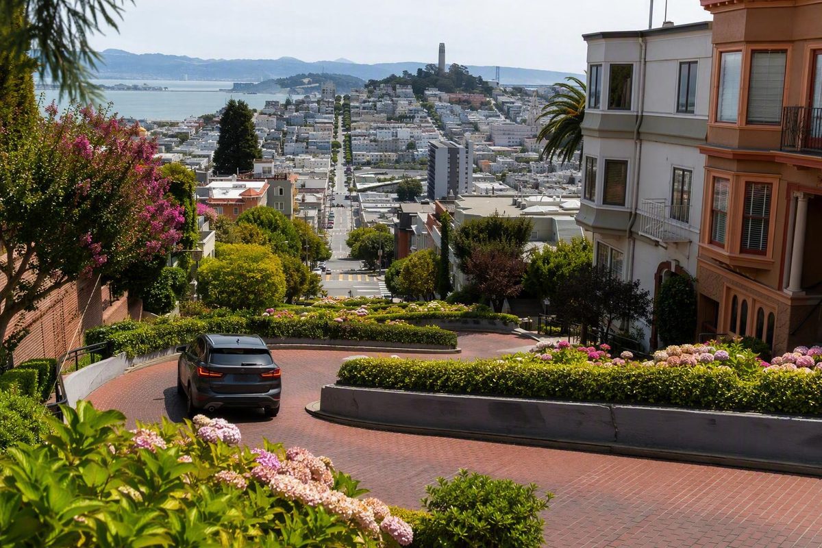
San Francisco’s Lombard Street is easy to recognize but surprisingly easy to approach badly. A map may show a short distance from the waterfront without conveying the climb. A search for “Lombard Street” may point to another part of the much longer road. Driving may sound convenient until parking uncertainty and a vehicle queue become part of the plan.
The simplest visit begins with four durable orientation facts: Hyde Street is the top, Leavenworth Street is the bottom, vehicles travel downhill through the curves, and pedestrians use the stairs and sidewalks beside the roadway. Once those points are clear, you can choose an arrival that suits your mobility, see one or both principal viewpoints, and leave in a useful direction instead of retracing a steep route.
This is an evergreen orientation guide rather than a source of live operating information. Transit service, street controls, closures, fees, reservations, and accessible arrival conditions can change, so confirm them through current official San Francisco sources before departure.
Start Here: The Famous Block, Top, Bottom, and Traffic Direction
Lombard Street orientation
- Landmark: One crooked block in Russian Hill
- Top: Lombard Street at Hyde Street
- Bottom: Lombard Street at Leavenworth Street
- Roadway: Eight hairpin turns
- Documented vehicle direction: One way downhill and eastbound, from Hyde toward Leavenworth
- Pedestrian route: Stairs and sidewalks along the sides, not the vehicle lane
- Useful map anchors: “Hyde and Lombard” and “Leavenworth and Lombard”
These location, turn-count, and traffic-direction details are documented by San Francisco Travel’s Lombard Street guide.
The famous San Francisco Lombard Street landmark is not the entire street. It is the single block between Hyde and Leavenworth Streets in Russian Hill, distinguished by its red-brick roadway, landscaping, and eight hairpin turns. Lombard Street continues far beyond the attraction, so entering only the street name into a map can produce an unhelpful destination.
Think of the block as a slope rather than a conventional street segment. Hyde Street forms the upper edge. Leavenworth Street forms the lower edge. Supplied visitor guidance describes vehicles entering at Hyde and moving one way downhill and eastbound toward Leavenworth. It does not describe vehicles entering from the bottom and climbing through the switchbacks.
Pedestrians have a separate route. Public stairways and sidewalks run beside the crooked roadway, allowing visitors to move between its ends without treating the vehicle lane as a path or photo platform.
The distinction matters when planning a transit arrival, pickup, or photography stop:
- Use Hyde and Lombard when you want the top of the curves.
- Use Leavenworth and Lombard when you want the bottom and the recognizable uphill composition.
- Do not use the full street name as your only navigation instruction.
- Confirm that a map pin refers to the Russian Hill block between Hyde and Leavenworth.
Visitors also sometimes confuse the crooked block with the lodging and motel corridor farther west on Lombard Street. That western stretch is another part of the same long road, not the switchback landmark. A hotel with “Lombard” in its address may therefore be separated from the curves by substantial distance and hills. Confirm the cross streets rather than relying on the shared street name.
A useful mental picture is simple: Hyde is high; Leavenworth is low. Vehicles move from high to low. Pedestrians can begin at either end, but their choice determines whether the stairs are an ascent or a descent.
Choose an Arrival Plan Before You Meet the Hill
The easiest way to reach Lombard Street is not necessarily the option with the shortest estimated travel time. Compare arrival modes by four more durable factors:
- Whether the trip leaves you at Hyde or below the attraction.
- How much climbing or stair use remains.
- Whether the plan depends on finding parking.
- Whether it exposes you to a vehicle queue.
Routes, stops, fares, service levels, and disruptions are time-sensitive. Use current official SFMTA planning and service information shortly before departure rather than relying on an undated timetable or a third-party travel estimate.
Powell-Hyde cable car: the most direct documented transit approach
The Powell-Hyde cable car is the clearest documented car-free option for a top-down visit. Visitor sources place its stop at Hyde and Lombard, beside the upper end of the crooked block. The cable car does not descend the switchbacks; it stops near them, after which visitors can view the block from Hyde or use a side stairway. Visit California documents the Powell-Hyde stop and the pedestrian stairs beside the roadway.
This approach is especially useful if you would rather descend than climb the block. It also creates a simple sequence: arrive at Hyde, take in the upper setting, walk down beside the curves, and finish with the uphill view from Leavenworth.
Current cable-car service is not established by the supplied evidence. Confirm the line, stop, fare, accessibility information, and service status with SFMTA before building your day around it.
Powell-Mason cable car: nearby, but not at the top
Supplied visitor sources place the Powell-Mason stop around Lombard Street and Columbus Avenue. From there, you still need to walk toward the crooked block. That remaining map distance should not be mistaken for a level connection.
Powell-Mason can make sense when it fits the rest of your itinerary, particularly if you are combining Lombard Street with North Beach. It is not equivalent to arriving at Hyde and Lombard, and its current service must also be verified.
Bus: potentially useful, but the final walk matters
Visitor sources identify bus approaches around Columbus Avenue and nearby neighborhoods. A bus can reduce the overall walking distance, but it may leave you below or east of the attraction with an uphill walk still to complete.
When reviewing a suggested bus trip, inspect the final walking segment rather than focusing only on the route number. Check the current official trip planner for the stop, fare, accessibility information, and service status. The supplied evidence does not establish which routes or stops will be operating on your travel date.
Rideshare or taxi: point-to-point, with caveats
A taxi or rideshare may reduce the approach walk and can work well for someone who wants to see the block from one end only. Enter a specific intersection—Hyde and Lombard or Leavenworth and Lombard—instead of merely requesting “Lombard Street.”
Do not assume that a particular curb is an authorized or accessible drop-off. Street controls, congestion, construction, and stopping restrictions can change. Follow current signs and the driver’s lawful judgment rather than requesting a stop that would obstruct traffic, a driveway, or a crossing.
Walking: geographically close does not mean physically easy
North Beach, Fisherman’s Wharf, and the northern waterfront appear close to Russian Hill on a map, but the approaches can be steep. A short route may demand more effort than its distance suggests.
If you are approaching from the waterfront, inspect the elevation pattern as well as the mileage. Walking uphill to the area and then climbing the crooked block from Leavenworth combines the approach hill with the block’s stairs. If that does not suit your plans, use transit or a vehicle for the uphill repositioning and reserve your walking for a top-down visit.
Car: direct in theory, parking-dependent in practice
Driving offers the distinctive experience of navigating the switchbacks. It also makes the visit dependent on current vehicle controls, traffic, and what you will do with the car after leaving the block.
Do not count on curb parking near either end. If your goals are to take photographs and see both principal viewpoints, arriving without a car will often give you more flexibility.
A practical decision rule
- Arrive at Hyde if you prefer a top-down visit, want to avoid climbing the crooked block, or want the upper outlook first.
- Arrive near Leavenworth if the classic uphill photograph is your priority and you are prepared either to use the stairs or to leave from the bottom.
- Use transit for the uphill repositioning when Lombard Street is one stop in a longer day.
- Separate arrival from departure. You do not have to return to the same intersection or use the same mode afterward.
Walking the Block: Stairs, Steep Approaches, and Mobility Limits
Walking gives you more freedom than driving to pause at the ends, observe the landscaping, and understand how the switchbacks fit into the hill. It does not remove the physical demands of the site.
Pedestrians use the stairways and sidewalks along the sides of the crooked roadway. Visitor guidance specifically describes those side stairs as the walking route and warns visitors to remain alert around cars. Visit California’s guide covers both pedestrian access and roadway precautions.
For visitors who prefer descending to climbing, the simplest sequence is:
- Begin at Hyde Street.
- Look over the block before committing to the stairs.
- Descend on one of the pedestrian sides.
- Keep landings and narrow passages clear.
- Finish at Leavenworth Street.
- Take the uphill photograph from a pedestrian position.
- Continue toward your next neighborhood or arranged transportation.
Descending stairs is not automatically suitable for everyone. Steps, steep grades, crowds, and the need to remain aware of nearby traffic may make a full traversal impractical. Judge the route according to your own mobility and comfort rather than assuming that downhill always means easy.
The supplied evidence does not establish a verified wheelchair-accessible route through the crooked block, a step-free connection between Hyde and Leavenworth, a designated accessible drop-off, accessible parking, a public bench, or a public restroom at a named location. Do not plan around any of those facilities without current official confirmation.
If you cannot comfortably manage the full stairs, treat Lombard Street as a one-end viewpoint:
- View the curves from Leavenworth without climbing the block.
- Arrive near Hyde for the upper perspective and leave from the same area.
- Arrange onward transportation rather than forcing a through-walk.
- Confirm current lawful and accessible drop-off conditions before departure.
That is not an incomplete visit. Hyde and Leavenworth provide different perspectives, and either can stand alone when a full traversal is unsuitable.
At the intersections, follow signals and watch for moving vehicles rather than simply following a crowd. On the stairs, keep the route passable and avoid stepping into the roadway to improve a photograph.
Plan the exit before arrival. Finishing at Leavenworth gives you a generally lower starting point for continuing toward North Beach or the waterfront, although connecting streets may still change grade. Finishing at Hyde leaves you high on Russian Hill and may make transit or a ride preferable to an unplanned walk.
Published visitor descriptions conflict over whether the hill’s original grade should be stated as a percentage or in degrees. Those units are not interchangeable, and the supplied evidence does not resolve the disagreement. The useful planning point is that the block and several approaches are steep enough for stairs and elevation to shape the visit.
Driving the Curves: What Is Established and What Must Be Checked
Supplied visitor sources describe the crooked block as a one-way downhill drive from Hyde Street toward Leavenworth Street. They also describe the public street as free to visit and drive. Because the evidence pack does not contain a current municipal operating source, treat those statements as documented visitor guidance rather than a guarantee of present-day access.
Before driving, check current city information for street controls, temporary closures, construction, fees, reservation requirements, and vehicle restrictions. Do not infer current rules for bicycles, scooters, tour buses, or oversized vehicles from general visitor descriptions.
A reservation system has been discussed publicly, but proposed rules should not be confused with operating rules. The San Francisco County Transportation Authority studied a paid vehicle-reservation program; the required state legislation was vetoed in October 2019. The agency’s latest supplied status update, from 2020, said it was working toward authorization for a no-fee alternative. The supplied evidence does not establish that either proposal was implemented. SFCTA documents that dated policy history on its Lombard Crooked Street project page.
Proposed prices, hours, staffing arrangements, and parking changes were planning concepts. They should not be presented as current visitor requirements. Equally, the absence of an implemented system in the supplied evidence does not prove that no newer restriction or temporary control exists.
Why driving may be less efficient than it sounds
Driving provides one experience walking cannot: navigating the turns from behind the wheel. If that is the central reason for your visit, accepting some inconvenience may be worthwhile.
For photography and sightseeing, a car can make the stop less flexible. The driver must concentrate on the narrow roadway and continue with traffic. The vehicle cannot serve as a place to stop for photographs, and a parking or departure plan is still necessary after exiting.
The block is also both a destination and a residential street. SFCTA has connected unmanaged visitor traffic with congestion, vehicle delay, pollution, safety concerns, and neighborhood livability. Those pressures are among the reasons vehicle-management systems have been studied. SFCTA’s project overview describes the documented transportation and neighborhood concerns.
Do not assume curb parking will be available near Hyde or Leavenworth. Garage availability, prices, opening hours, clearance limits, and access conditions are time-sensitive, so no undated garage recommendation should be treated as dependable.
Choose driving when:
- Navigating the switchbacks is itself a priority.
- The driver is comfortable on steep urban streets.
- You have checked current access conditions.
- You have a realistic plan for the vehicle after exiting.
Choose walking or transit when:
- You want photographs from both ends.
- You want time to observe the curve pattern.
- You do not want the visit to depend on parking.
- You would rather avoid a possible vehicle queue.
- The driver wants to experience the views rather than concentrate on the road.
If you drive, obey current signs and controls, remain attentive to pedestrians, and continue through rather than stopping for photographs. Check for closures, construction, special-event controls, and other restrictions before setting out.
A Two-Viewpoint Photo Plan Without Standing in Traffic
Lombard Street makes the most visual sense from its two ends. The lower and upper viewpoints serve different purposes.
Leavenworth Street at the bottom is commonly recommended for the recognizable uphill composition. Looking west and uphill from this end brings the red-brick curves, landscaping, roadway, and hillside homes into one view.
Hyde Street at the top provides a different kind of context, including outward views associated with the city and bay. A visitor guide that distinguishes these two perspectives identifies Leavenworth for the classic uphill image and Hyde for the broader outlook. StoryHunt describes the two principal Lombard Street viewpoints.
A simple two-viewpoint sequence is:
- Arrive at Hyde.
- Orient yourself at the top.
- Photograph the outward setting.
- Descend on a side stairway.
- Continue to Leavenworth.
- Turn back uphill from a safe pedestrian area.
- Take the full switchback photograph without blocking circulation.
Early morning is frequently recommended for softer light and fewer people or cars, but it guarantees neither. Weather, maintenance, commuter activity, tours, traffic, and other visitors can alter the scene quickly.
The block’s appearance also changes with light and season. Fog can obscure the distant backdrop. Bright sunlight can create strong shadows across the turns. Landscaping and traffic can change how much of the brick pattern is visible. Build the plan around the two viewing positions rather than expecting a specific image.
From below, a wider composition can capture more of the curve pattern without requiring you to move toward the roadway. At Hyde, use the upper stop for context rather than trying to recreate the same image from a less suitable angle.
No photograph requires you to:
- Step into the vehicle lane.
- Stand in an intersection.
- Block a stairway, sidewalk, garage, or driveway.
- Enter a flowerbed.
- Pose on private steps.
- Approach a home’s windows.
- Ask a driver to stop in the curves.
The available public space is narrow and shared. Frame the image, take your photographs, and move on. If a viewpoint is crowded, wait away from the pedestrian flow rather than forming another obstruction.
Why the Street Has Eight Turns—and Why the Nickname Misleads
The curves were not introduced merely as decoration. The switchbacks were built during the 1920s to make a very steep block more manageable for vehicles. Lengthening the path and breaking the descent into repeated turns changed how cars could negotiate the hill.
Several accounts give 1922 as the construction date, while others identify only the decade. Historical attribution is also inconsistent: some accounts emphasize a property owner who proposed the idea, while others credit local residents more broadly. Without a primary construction record in the supplied evidence, 1922 is best described as a commonly reported date rather than an independently verified one. Big Bus Tours summarizes the frequently told 1920s origin story and the eight-turn design.
The resulting combination became memorable:
- Eight closely spaced hairpin turns occupy one block.
- Red-brick paving distinguishes the roadway.
- Landscaping outlines and softens the switchbacks.
- Russian Hill supplies the dramatic elevation change.
- Views from the ends give the block a setting beyond the road itself.
Lombard Street is often called “the crookedest street in the world,” but that phrase is a popular nickname rather than a verified engineering title. The supplied evidence contains no worldwide survey, agreed definition of crookedness, or consistent measurement method capable of establishing such a ranking.
Vermont Street in Potrero Hill is frequently proposed as a more crooked San Francisco street. That comparison also lacks a shared methodology in the available evidence. “Crookedest” might refer to the number of turns, turn density, curvature, length, grade, or a combination of measurements. A travel-company history presents Vermont Street as a rival but does not supply an objective test that determines a winner. ExperienceFirst discusses the disputed nickname and Vermont Street comparison.
The nickname persists because it is vivid. Lombard’s more defensible distinction is the recognizable combination of switchbacks, brick paving, landscaping, hillside homes, and prominent views.
There is also no need to choose between conflicting descriptions of the original grade. Some supplied sources use a percentage and others use degrees. Repeating either as definitive would create false precision. For visitors, the relevant point is that the hill motivated an unusual roadway design and remains physically demanding on foot.
Turn a Short Landmark Stop Into a Coherent Half Day
The crooked block works best as a focused stop within a larger route. It does not need to occupy an entire sightseeing day, and trying to add every nearby attraction can create unnecessary climbing and backtracking.
A compact photo-stop plan
- Arrive at Hyde and Lombard.
- Take in the upper perspective.
- Descend beside the roadway.
- Photograph the curves from Leavenworth.
- Continue toward one selected area.
That sequence captures both ends without requiring an immediate return climb. If you must finish near your starting point, consider using transit or a ride for the repositioning rather than automatically walking back uphill.
Option 1: Continue toward the waterfront
From the lower end, you can orient toward Fisherman’s Wharf or Ghirardelli Square. This gives the day a broadly downhill continuation after Lombard Street, although individual connecting streets may still rise or fall.
The warning is more important in the opposite direction: walking from the waterfront to Lombard Street can be much harder than the map distance suggests. If Lombard is the first stop, consider reaching the top by transit and walking toward the water afterward.
PIER 39 can also fit into a waterfront-oriented day. Treat it as an additional destination, not as a mandatory stop simply because it appears nearby.
For a separate outing centered on shoreline scenery rather than Russian Hill, use the self-guided Golden Gate waterfront walk. It is an alternative half-day plan, not a direct continuation of the crooked block.
Option 2: Continue toward North Beach
North Beach is a natural choice when food, cafés, and neighborhood streets matter more than waterfront attractions. From the Lombard area, commit to that direction rather than descending toward the bay and later reversing course.
Chinatown can follow North Beach on a longer day, but it should be an intentional extension. Consider the connecting streets and decide how you will return to your hotel before adding it.
Option 3: Pair Lombard with one hilltop or indoor stop
The Cable Car Museum or Grace Cathedral may suit a day organized around cable cars, Russian Hill, or Nob Hill. They are not automatically efficient additions to a waterfront route, and reaching them may involve more elevation.
The strongest half-day usually follows one theme:
- Lombard plus the waterfront.
- Lombard plus North Beach.
- Lombard plus a cable-car or hilltop area.
- Lombard as a short stop before an unrelated destination reached by transit.
The hill-smart rule is to select one useful direction after the block. A nearby attraction is not automatically a sensible walking detour. Use transit for a steep repositioning or save the extra destination for another day.
Visit Like a Guest on a Residential Block
Lombard’s curves are a public attraction, but the block is also lined with private homes. Residents use the same doors, garages, sidewalks, and intersections that visitors are photographing. Neighborhood etiquette is therefore part of the visit.
Residential-block checklist
- Stay out of the roadway.
- Remain off private property.
- Keep garages and driveways clear.
- Do not enter or touch flowerbeds.
- Take litter away.
- Keep voices and music down.
- Respect residents’ privacy.
- Do not look through windows.
- Do not pose on private steps.
- Do not ask vehicles to stop for photographs.
- Keep stairs and sidewalks passable.
San Francisco Travel specifically asks visitors to avoid blocking driveways, entering private property or flowerbeds, making excessive noise, leaving litter, or looking through residents’ windows. Its Lombard Street guidance explains these neighborhood expectations.
Pedestrians should continue watching for cars while concentrating on the curves or skyline. At the top and bottom, remain in pedestrian areas rather than drifting into an intersection for a wider angle. On the stairs, avoid stopping where others cannot pass.
Drivers should proceed cautiously, follow current signs and controls, and give pedestrians space. Avoid repeatedly circling the surrounding residential streets in search of curb parking. If parking is essential, identify and verify a lawful alternative before entering Russian Hill.
These choices matter because the documented pressures extend beyond inconvenience. Visitor traffic has been associated with congestion, delay, pollution, safety concerns, and neighborhood livability. Responsible behavior cannot eliminate those pressures, but it can prevent an individual visit from adding unnecessary obstruction or intrusion.
Verify on the day you travel
Check current official San Francisco information for:
- Cable-car and bus service
- Stops, fares, and disruptions
- Municipal street-access rules
- Temporary closures and construction
- Vehicle fees, controls, or reservation requirements
- Lawful and accessible drop-off conditions
- Weather that may affect visibility or the outdoor route
The supplied evidence does not provide current first-party confirmation of these time-sensitive details.
Frequently Asked Questions
Is Lombard Street free to visit, and do drivers need a reservation?
Available visitor guides describe the crooked block as a free public street and say there is no charge to walk or drive it. The supplied evidence does not establish an implemented reservation requirement, but it also does not provide current municipal confirmation that vehicle access remains unrestricted. StoryHunt is one of the supplied visitor guides describing the block as free and publicly accessible.
The latest supplied official policy update is from 2020. It followed the October 2019 veto of legislation that would have authorized a paid reservation pilot and discussed seeking authorization for a no-fee alternative. Check current city rules before driving, and do not treat proposed prices or hours as present-day requirements.
Which way do cars travel on the crooked block?
Supplied visitor guidance describes cars traveling one way downhill and eastbound, entering the crooked section from Hyde Street at the top and exiting at Leavenworth Street at the bottom. Follow current posted signs and controls, which take precedence over any visitor guide.
Does the Powell-Hyde cable car go down Lombard Street?
No. Supplied guides place the Powell-Hyde stop at Hyde and Lombard near the top of the crooked block. The cable car does not travel through the switchbacks. Visitors continue from the stop on foot if they want to descend beside the curves. ExperienceFirst also describes the Hyde-line stop near the top of the block.
Confirm current service, fares, stop conditions, and disruptions through SFMTA before departure.
Is Lombard Street accessible without using the stairs?
You can view the block from one end without traversing all the stairs. However, the supplied evidence does not establish a verified step-free connection between Hyde and Leavenworth, nor does it confirm a named accessible drop-off, parking space, bench, or public restroom at the landmark.
If stairs or steep grades are a concern, choose one viewpoint, arrange onward transportation, and confirm current accessible access and lawful drop-off conditions through official local sources.
Is Lombard Street really the crookedest street in the world?
“The crookedest street in the world” is a popular nickname, not a verified ranking. Vermont Street in Potrero Hill is often cited as a more crooked alternative, but the supplied comparisons do not use a shared definition or measurement method.
Lombard Street’s fame rests on its recognizable combination of eight hairpin turns, red-brick paving, landscaping, Russian Hill scenery, and contrasting views from the top and bottom.
The off-map plan is easy to remember: choose Hyde or Leavenworth as your arrival point, account for the stairs before choosing a direction, favor transit when driving would add parking uncertainty or congestion, see both ends if mobility permits, and continue toward only one nearby area. Verify current transit, street access, closures, fees, reservations, and accessible arrival conditions before departure—and remember that the curves are an attraction, but the block remains someone’s neighborhood.