
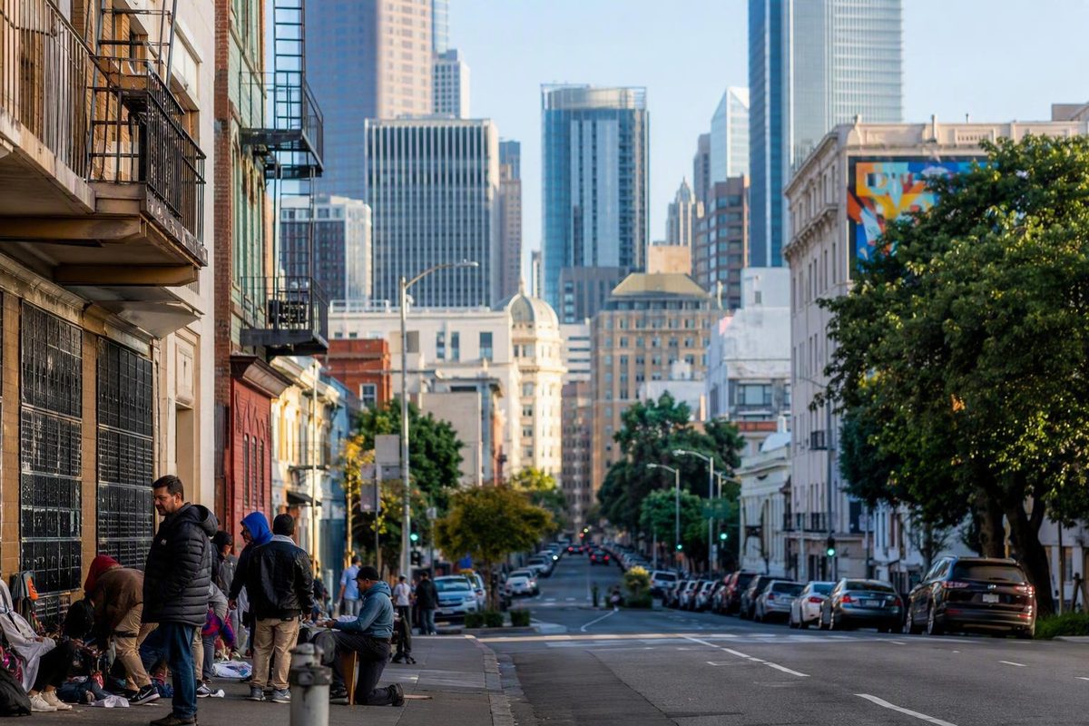
The Tenderloin is difficult to explain with a single label. It is also associated with homelessness, open-air drug activity, fentanyl use, sidewalk encampments, and street crime.
Neither description cancels the other.
For visitors, the useful questions are more specific than “Is the Tenderloin good or bad?” Where is it? Why do maps and hotel listings describe its edges differently? What makes it historically important? Is visiting a cultural site there the same decision as choosing a hotel there?
This guide focuses on location, history, culture, housing, and general visitor-planning considerations. It uses historic boundaries for orientation rather than treating them as definitive present-day lines. It does not provide current block-by-block safety ratings, confirm venue operations, or promise that any route is safe.
Tenderloin at a glance: location, boundaries, and scale
The Tenderloin is in downtown San Francisco, between Union Square to the northeast and Civic Center to the southwest. The Tenderloin is a neighborhood in downtown San Francisco, in the flatlands on the southern slope of Nob Hill Tenderloin in San Francisco, CA, United States - Apple Maps.
A commonly cited historic boundary framework is:
- Geary Street to the north
- Mason Street to the east
- Market Street to the south
- Van Ness Avenue to the west
These are historic boundaries, not universally accepted present-day lines. They work best as an orientation box rather than a legal perimeter or a guarantee that every resident, institution, map service, or travel publisher uses the same definition. Apple Maps uses this four-street historical framework and places the neighborhood between Union Square and Civic Center.
Published estimates of the neighborhood’s size illustrate the uncertainty. Apple Maps describes roughly 50 square blocks, while an April 2025 Beyond Chron account uses a 33-block definition. The discrepancy reflects two different published descriptions rather than an error that can be conclusively resolved.
For practical orientation, think of the Tenderloin as a compact downtown district with permeable edges. The historic framework explains where it sits, but it cannot establish exactly where every contemporary neighborhood label begins or ends.
Reading a Tenderloin map
Look for Geary Street, Mason Street, Market Street, and Van Ness Avenue as approximate historic edges. Union Square lies to the northeast, Civic Center to the southwest, and Nob Hill to the north and uphill. Cultural and preservation districts should be treated as separate layers rather than alternative names for the entire neighborhood.
Older population and density figures sometimes appear in neighborhood summaries, but they should not be used as current statistics. In addition to being dated, those figures may depend on a boundary definition that differs from the one used elsewhere.
How the Tenderloin relates to nearby downtown neighborhoods
The Tenderloin does not exist as a perfectly isolated polygon. It sits among downtown labels that may describe residential neighborhoods, visitor districts, commercial corridors, cultural areas, or historic-preservation zones. Those categories can overlap without meaning the same thing.
Union Square lies to the northeast and works well as a visitor orientation point. Civic Center lies to the southwest. Saying the Tenderloin is “between Union Square and Civic Center” is more useful than pretending there is universal agreement about every contemporary edge.
Lower Nob Hill is adjacent to the Tenderloin. Some travel publishers caution readers to inspect addresses near that transition carefully, but those descriptions are broad travel judgments rather than official boundary or safety determinations. The available evidence does not establish definitive current borders for Lower Nob Hill, Mid-Market, or every district that overlaps or adjoins the Tenderloin.
This ambiguity matters when booking a hotel. A listing platform may use a familiar or marketable district name that covers a wider area than residents would recognize. “Union Square,” “Lower Nob Hill,” “downtown,” and “Civic Center” can all appear in descriptions of properties relatively close to the Tenderloin. The neighborhood label is only a starting point; the street address and entrance are more informative.
Before booking, check:
- The property’s complete address, not just its neighborhood category.
- The location of the entrance you would actually use.
- The hills, transit connections, and pickup options relevant to your plans.
- Recent information about the immediate surroundings.
- Whether the location fits your mobility needs and personal comfort level.
Do not assume that crossing one named street produces an immediate or uniform change. Downtown environments often change gradually, and conditions can differ by block, building entrance, day, and time. The supplied evidence does not support a block-by-block ranking.
How overlapping labels differ
- Historic neighborhood boundaries are inherited orientation frameworks, such as the Geary–Mason–Market–Van Ness outline.
- Colloquial neighborhood labels are names used by residents, businesses, maps, and travel publishers. Their edges can shift.
- Cultural districts recognize and support particular communities, histories, businesses, and institutions. They may occupy only part of a neighborhood or cross a neighborhood line.
- Historic-preservation districts identify groups of buildings or other resources for preservation purposes. They are not synonymous with a neighborhood’s social or commercial identity.
A property can therefore sit near a historic boundary, fall within a preservation district, and be marketed under an adjacent neighborhood name at the same time.
The practical lesson is not that one label must be wrong. It is that “neighborhood” can mean different things depending on whether the speaker is discussing history, culture, planning, real estate, or visitor convenience.
A residential neighborhood with more than one story
Public discussion often treats the Tenderloin as scenery: either a zone tourists should avoid or a gritty setting for a story about resilience. Both approaches can erase the people who live there.
The Tenderloin has long been a downtown residential community. Its history includes working-class residents, immigrant families, Vietnamese American residents and merchants, LGBTQ and transgender communities, and people living in single-room-occupancy hotels. It contains homes, neighborhood businesses, cultural organizations, social-service providers, theaters, religious and community institutions, and historic buildings.
It also faces serious street-level problems. Supplied reporting associates the neighborhood with homelessness, sidewalk encampments, open-air drug markets, fentanyl use, and crime. Acknowledging those conditions is not an attack on residents. Nor should those conditions be used to suggest that everyone on the street is dangerous or that the neighborhood has no identity beyond visible hardship.
That distinction matters because residents and visitors experience neighborhood conditions differently. A traveler might ask whether a sidewalk feels comfortable for a short walk. A parent, SRO tenant, merchant, disabled resident, or service worker may instead be concerned with reliable access to a home, school, business, clinic, or transit stop. Visitor comfort is not the only measure of neighborhood conditions.
The April 2025 Beyond Chron review cited earlier used an estimate of approximately 3,000 children in the Tenderloin. That figure was presented in a favorable neighborhood history and should not be treated as a verified current count; the source does not establish a current boundary-specific demographic total. Its more limited significance is that the Tenderloin has been described as a family neighborhood even when outside coverage focuses mainly on adults in crisis.
Visitors should also resist turning hardship into an attraction. Photographing or staring at people experiencing homelessness, intoxication, illness, or distress is intrusive. A respectful visit focuses on public architecture, documented historical sites, cultural institutions, and businesses that invite customers inside.
No single neighborhood-wide verdict can describe present conditions. One block may look and feel different from the next, and circumstances can change over time. The evidence does not justify a blanket statement that the Tenderloin is safe during one part of the day, unsafe during another, or uniform throughout.
Understanding the neighborhood requires holding several realities together: it is residential, culturally significant, historically important, economically varied, and affected by severe social problems.
From post-Gold Rush settlement to a rebuilt entertainment district
The Tenderloin’s residential history reaches back to the period shortly after the 1849 California Gold Rush.
The physical neighborhood visible today was shaped profoundly by the 1906 earthquake and fires. A reference history reports that almost all neighborhood buildings were destroyed by the disaster and related firefighting backfires, followed by rapid reconstruction. The same account records the San Francisco Symphony’s first concert at the Cort Theatre on December 8, 1911. These events help explain the Tenderloin’s concentration of early-20th-century apartment buildings, hotels, theaters, and commercial structures, although the source is a tertiary reference and should not substitute for archival documentation.
Rebuilding did more than replace lost housing. Beyond Chron’s historical portrait associates the Tenderloin at different times with brothels, Prohibition-era speakeasies, early gay bars, jazz clubs, hotels, film and recording businesses, and boxing gyms. That is a selective account rather than a complete chronology, but it conveys the neighborhood’s long role in nightlife, lodging, performance, and communities excluded from more conventional districts.
The Symphony’s 1911 concert is one concise illustration of that history. The presence of a major cultural institution’s first performance complicates the idea that the Tenderloin has always existed outside San Francisco’s formal cultural life.
The neighborhood’s hotels also served more than one purpose. That relationship between hotel architecture and residential life remains central to understanding the Tenderloin.
The origin of the neighborhood’s name is less certain than some colorful retellings suggest. San Francisco adopted “Tenderloin” from an older New York district associated with nightlife, vice, and police corruption, but competing explanations survive for why the New York area acquired the name.
One frequently repeated story says police officers assigned to a profitable district could afford better cuts of beef—or obtained premium meat through bribes. It is memorable, but it is not a settled etymology. The most accurate conclusion is that San Francisco borrowed the name while the original explanation remains disputed.
What is clearer is the social meaning the word accumulated. “Tenderloin” became shorthand for an entertainment district operating near the boundaries of respectability and regulation. Yet the neighborhood was never only a nightlife quarter. It was also a place where people rented rooms, raised families, ran shops, organized as tenants, made art, and built community.
Compton’s Cafeteria and the Transgender Cultural District
The Tenderloin occupies an essential place in transgender civil-rights history.
In August 1966, transgender patrons and other community members protested police harassment at Compton’s Cafeteria at Turk and Taylor streets. The confrontation occurred three years before the 1969 Stonewall uprising in New York. Placing Compton’s earlier in time provides useful historical context, but it should not be turned into a competition in which one event diminishes another.
Compton’s emerged from conditions particular to the Tenderloin.
The neighborhood’s transgender history did not begin or end that night.
In 2017, three Black trans women founded what was initially called the Compton’s Transgender Cultural District. SF Heritage describes the Transgender District as the world’s first legally recognized transgender district and reports that the former cafeteria site at 101 Taylor Street entered the National Register of Historic Places in January 2025. Its Tenderloin profile documents the August 1966 protest, the district’s 2017 founding, and the site’s 2025 National Register recognition.
A cultural district is not merely a collection of attractions. It can provide a framework for preserving histories that conventional landmark programs have overlooked. It can also support cultural programming and community-serving initiatives while drawing attention to tenant protection, accessibility, displacement, and the survival of businesses and organizations.
That broader purpose should shape a visitor’s approach. Seeing the former Compton’s site can be meaningful, but the appropriate frame is civic and community history rather than a casual photo stop. Read interpretive material where available, avoid obstructing entrances or sidewalks, and remember that culturally significant streets remain places where people live and work.
“Transgender” is the appropriate contemporary umbrella term in this context, although historical sources may use different language for participants and communities. Visitors should not treat the people involved as characters from a finished past. The district’s history remains connected to present questions about housing, safety, public space, economic opportunity, and cultural continuity.
Compton’s is a crucial landmark, but it is not the Tenderloin’s sole LGBTQ contribution. Early gay bars, residential networks, nightlife, activism, arts, and community institutions also formed part of the neighborhood’s history. A fuller account recognizes the landmark event while leaving room for those longer and more varied stories.
Little Saigon, theaters, and historic architecture
The Tenderloin’s cultural landscape can be read through several overlapping layers: Vietnamese American commerce, transgender history, entertainment venues, residential hotels, apartment buildings, theaters, bars, and preservation districts.
Little Saigon
Little Saigon recognizes Vietnamese American residents and businesses established in the area since the 1970s. Its exact extent varies by source. SF Heritage identifies a two-block Larkin Street corridor between Eddy and O’Farrell streets as designated in 2003, while another supplied description includes parts of Larkin and Hyde streets between Turk and O’Farrell. SF Heritage also records the installation of granite gateway pillars topped by marble kỳ lân in 2008. These descriptions support treating Little Saigon as both a designated corridor and a broader community landscape rather than forcing one undisputed border.
The gateways are useful visual markers, but the district is more than an architectural entrance. It represents decades of residence, migration, enterprise, food culture, and community life.
Visitors should approach Little Saigon as a living business and residential district. Patronize businesses respectfully, do not assume every establishment is open, and verify hours and accessibility directly before making a special trip. Avoid dining superlatives that reduce a community district to a search for the supposed “best” meal in the city.
The Uptown Tenderloin Historic District
According to the same SF Heritage profile, the Uptown Tenderloin Historic District entered the National Register of Historic Places in 2009 with 409 contributing buildings. The scale of that inventory helps explain why the area can feel architecturally coherent even though individual buildings vary in use and condition.
Some properties are individually prominent; others matter mainly as part of a larger ensemble.
The SF Heritage profile highlights several examples:
- Alcazar Theater, 650 Geary Street: Built in 1917 and designated San Francisco City Landmark No. 195.
- Alhambra Apartments, 860 Geary Street: Built in 1914 and associated with the neighborhood’s early-20th-century apartment development.
- Ha-Ra Club, 875 Geary Street: Located in a 1922 Spanish Colonial Revival building that contributes to the historic district.
These facts establish architectural and historical significance, not current visitor access. A theater may have a changing performance schedule; a bar or business may alter its hours or operations; and an apartment building is a private residence, not an attraction. Observe residential properties from public space without entering, lingering in doorways, or photographing occupants.
Theaters, entertainment, and cultural institutions
The neighborhood’s theater history belongs to a wider entertainment tradition involving music, nightlife, film, recording, and performance. That history survives in buildings and documented stories even as individual venues change use.
An April 2025 account associated the Tenderloin Museum with exhibitions, theater, walking tours, and other cultural programming. That dated description does not confirm current operations. Before visiting the museum—or any theater, tour, restaurant, bar, or cultural venue—verify operating status, hours, admission requirements, program availability, and physical accessibility directly.
A history-focused visit could connect Little Saigon’s gateways, the exterior of the former Compton’s Cafeteria site, selected Geary Street buildings, and interpretive programming at a cultural institution. That is a thematic outline, not a recommended safety route. Current conditions, closures, construction, access, and personal comfort should determine whether and how to connect the stops.
Architecture is especially useful here because it reveals the Tenderloin as a built residential district rather than an abstract reputation. Its apartment buildings and SRO hotels are not merely picturesque remnants.
SRO housing, tenant organizing, and resistance to displacement
SRO means single-room occupancy.
SROs are central to the Tenderloin’s residential landscape. Their affordability and condition are not uniform, and preserving a room does not by itself resolve questions about habitability, services, accessibility, or long-term security.
Tenant organizing has therefore shaped the neighborhood alongside architectural preservation. Nonprofit acquisition of SRO buildings has been one response intended to stabilize housing and connect tenants with support.
The 2025 Beyond Chron review describes the Tenderloin Housing Clinic as acquiring and developing SRO properties and providing subsidized housing and support services to several thousand tenants. Because the article is a favorable review of a book by clinic co-founder Randy Shaw, its broader assessment of the clinic’s policy success should be understood as a pro-tenant and pro-organizing interpretation rather than a neutral impact evaluation.
The early-1980s hotel dispute
An early-1980s development fight offers a concrete example of neighborhood organizing. According to Beyond Chron, residents responded to proposed luxury hotels associated with Hilton, Holiday Inn, and Ramada by demanding commitments intended to benefit the existing community.
The reported agreement required each hotel to:
- Contribute $320,000 annually for 20 years toward lower-cost housing development.
- Support a $4 million federal grant for the acquisition and renovation of four Tenderloin SRO properties.
- Pay $200,000 for community-service projects.
- Give neighborhood residents priority for jobs.
The Beyond Chron account presents the SRO work and hotel agreement as major organizing achievements, but its conclusions about long-term policy effectiveness are interpretive. The reported commitments illustrate what organizers sought and obtained; they do not independently demonstrate that every intended outcome was achieved.
The dispute connects two aspects of the Tenderloin that visitors might otherwise view separately. New hotels can serve downtown tourism, while nearby SROs serve long-term residents. Development therefore raises questions not only about design and visitor demand but also about land values, displacement, employment, public services, and who benefits from investment.
Housing preservation has helped sustain the Tenderloin’s economic and cultural diversity. When lower-cost rooms disappear, residents can be displaced along with the relationships, businesses, institutions, and organizing networks they support.
Preservation is not a complete solution, however. A building can remain standing while tenants face unaffordable rents, inaccessible entrances, poor conditions, or weak protections. Nonprofit ownership can offer stability without eliminating the larger shortage of affordable and accessible housing. Cultural recognition can raise visibility while also creating concerns about investment and displacement.
That tension is part of the neighborhood’s history. The Tenderloin is not simply a place where old buildings survived. It is a place where residents repeatedly organized over what those buildings would be used for and who would be able to remain in them.
Should a visitor stay in the Tenderloin, visit it, or both?
Three decisions are often conflated:
- Understanding the Tenderloin as part of San Francisco’s history.
- Visiting a cultural institution, business, landmark, or public event there.
- Choosing the neighborhood as a lodging base.
A traveler can decide that the Tenderloin is historically important without choosing to stay there. Someone may also visit a confirmed cultural program without making the neighborhood a general sightseeing route. Conversely, a person familiar with dense downtown environments may evaluate a particular lodging address differently from a first-time visitor.
Choosing a hotel
Several travel publishers advise first-time visitors not to stay in the Tenderloin. These are subjective travel judgments, not official safety conclusions. One longtime-resident guide explicitly presents its recommendations as personal opinion and warns that booking-platform neighborhood labels can be inaccurate. Its practical advice is to inspect the map and exact address rather than trust a marketing label alone.
Union Square is commonly presented as a more conventional first-time visitor base because it has a substantial concentration of hotels and useful transit connections. That does not mean every Union Square address is identical, objectively safer, or appropriate for every traveler. Its practical advantage is that it is an established lodging district with more visitor-oriented inventory.
Nob Hill is another frequently recommended alternative. Travel writers emphasize its character and transit connections while also noting its tradeoffs: steeper hills, potentially higher prices, and fewer lodging choices. One lodging guide favors Nob Hill but describes Union Square as especially convenient for first-time visitors.
Lower Nob Hill can create particular confusion because it borders the Tenderloin and may appear under different labels in hotel listings. Broad tourism descriptions of that transition do not provide a definitive border or a block-level assessment.
Before booking, compare the exact address with the places you expect to revisit. Consider hills, transit, evening returns, pickup logistics, mobility requirements, and personal comfort. San Francisco Know’s guide to choosing a neighborhood base provides a broader framework for comparing areas by hills, transit, and repeat destinations.
Visiting for history or culture
A focused cultural visit is a different decision from using the neighborhood as a base. Someone interested in transgender history, Little Saigon, theater architecture, SRO housing, or tenant organizing may find the Tenderloin important to understanding San Francisco.
Plan around confirmed destinations rather than relying on an improvised route. Before leaving:
- Confirm that the destination is operating.
- Check current hours, admission rules, and accessibility.
- Review current local information relevant to the visit.
- Decide how you will arrive and leave based on present conditions.
- Keep the plan flexible enough to change if the immediate environment feels uncomfortable.
- Avoid assuming that advice from several years ago still describes a street today.
Pedestrian conditions require the same attention to dates. A Walk San Francisco article published in July 2020 reported four pedestrian deaths in the Tenderloin in 2019 and said every neighborhood street was then designated high-injury. That report documents a serious historical traffic-safety concern, but it does not establish current designations, street configurations, projects, or pedestrian risk.
What can—and cannot—be said about safety
The available evidence cannot support:
- A current block-by-block safety ranking.
- A universal day-versus-night rule.
- A statement that every part of the Tenderloin is unsafe.
- A guarantee that a cultural destination or route is safe.
- A conclusion that crossing a particular street immediately changes the risk.
- A promise that Union Square or Nob Hill is objectively safer.
Bounded planning is more responsible. Consult current information, remain aware of your immediate surroundings, and choose transportation according to present conditions and your comfort level. If a situation appears unstable, do not continue merely because an article or map suggested a destination.
Respect matters as much as awareness. Keep sidewalks and entrances clear. Do not photograph people in distress. Do not treat residents, outreach workers, merchants, or service providers as part of a spectacle. If you enter a business or attend a program, behave as a customer or guest rather than an observer of someone else’s hardship.
Tenderloin FAQ
Where are the historic boundaries of San Francisco’s Tenderloin?
The commonly cited historic framework places Geary Street to the north, Mason Street to the east, Market Street to the south, and Van Ness Avenue to the west. These are useful orientation points, not universally accepted current boundaries.
The Tenderloin lies between Union Square to the northeast and Civic Center to the southwest, below Nob Hill. Published descriptions place its scale at roughly 33 blocks in one account and approximately 50 square blocks in others. Because the sources may be using different definitions, it is better to treat the edges as approximate than to insist on one exact count.
Is the Tenderloin safe for visitors?
No responsible neighborhood-wide guarantee is possible from the available evidence. Reporting associates the Tenderloin with serious street-level challenges, but those conditions are not necessarily uniform across every block or time.
Visitors should check current information, plan around a confirmed destination, remain aware of their immediate surroundings, and select transportation according to present conditions and personal comfort. The evidence does not support a universal claim that the neighborhood is safe by day, unsafe after dark, or categorically unsafe at all times.
Should a first-time visitor stay in the Tenderloin or nearby Union Square?
Several travel publishers recommend that first-time visitors choose Union Square or another conventional lodging district instead of the Tenderloin. That advice is subjective rather than an official safety finding.
Union Square generally offers a larger concentration of hotels and useful transit connections, which can simplify a first trip. The most informative comparison is nevertheless between exact addresses, not broad neighborhood names. Check the entrance location, hills, transportation options, return plans, and whether the immediate setting fits your comfort and mobility needs.
What historically significant places are associated with the Tenderloin?
Important places and districts include:
- The former Compton’s Cafeteria site at 101 Taylor Street.
- The Transgender District.
- Little Saigon and its gateway pillars.
- The Uptown Tenderloin Historic District.
- The Alcazar Theater at 650 Geary Street.
- The Alhambra Apartments at 860 Geary Street.
- The 1922 building occupied by the Ha-Ra Club.
- The Tenderloin Museum.
- The neighborhood’s SRO hotels and early-20th-century apartment buildings.
Not all are conventional attractions. Some are private residences, operating businesses, or exterior-only historical sites. Verify current public access, hours, admission, programming, and accessibility before visiting.
How did the Tenderloin get its name?
San Francisco borrowed the name from New York City’s earlier Tenderloin district. The original New York name has competing explanations, many involving the money or corruption associated with policing a nightlife and vice district.
A popular story connects the name to police officers obtaining or affording premium cuts of beef. It is colorful but disputed and should not be treated as the definitive origin.
The Tenderloin’s reputation is not invented, but reputation is not understanding. The neighborhood is historically significant, culturally layered, residential, and affected by serious social and street-level problems at the same time. Use its historic boundaries as an orientation tool, verify current destinations and conditions, evaluate lodging by exact address and personal comfort, and approach any visit with awareness and respect rather than expecting a simple safe-or-unsafe verdict.