
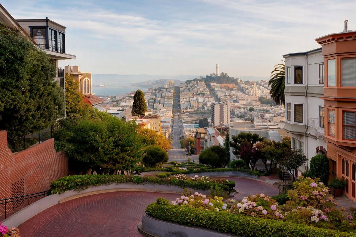
Quick answer: The famous crooked street is not all of Lombard Street. It is the single block between Hyde Street at the top and Leavenworth Street at the bottom, in San Francisco’s Russian Hill neighborhood. For the simplest car-free visit, arrive at Hyde and Lombard, walk down a public side stairway, and take the classic uphill photograph from Leavenworth Street.
Operational-status note, August 2026: This guide covers the block’s stable layout and hill-smart planning principles. The available evidence does not establish day-of-visit cable-car service, bus operations, vehicle access, construction controls, parking conditions, or a verified step-free route. Check current SFMTA service information, posted signs, and City of San Francisco notices before setting out.
Start with the right block: Hyde Street to Leavenworth Street
Searching for “crooked street Lombard” can lead to several map pins because Lombard Street is a long east–west corridor, not a one-block attraction. The landmark visitors usually mean is the block with eight sharp turns between Hyde and Leavenworth streets. San Francisco Travel identifies those intersections as the boundaries of the famous section and distinguishes it from the rest of Lombard Street. See San Francisco Travel’s Lombard Street orientation.
Use the intersections in your map rather than relying on a single street number. Mapping and visitor pages use different destination addresses, including 1018 and 1070 Lombard Street. Those pins may place you in the general area, but the supplied evidence does not establish any one number as the official entrance.
The intersections are more useful because they identify both the correct block and the end you are approaching:
- Hyde and Lombard is the upper end. It is the vehicle entrance, the Powell–Hyde cable-car arrival point, and the better starting place for a downhill pedestrian visit.
- Leavenworth and Lombard is the lower end. It provides the familiar uphill view of the switchbacks but leaves the top of the block above you.
- Vehicles move from Hyde toward Leavenworth. They do not enter from the bottom and drive uphill through the curves.
- Pedestrians use the side stairs or sidewalks. The winding roadway remains an active vehicle lane.
If minimizing exertion matters most, start at Hyde and descend once. If seeing the recognizable zigzag immediately matters more, begin at Leavenworth—but expect a steep ascent if you then continue to Hyde.
Crooked Lombard Street at a glance
| Fact | What to know |
|---|---|
| Neighborhood | Russian Hill |
| Famous section | One block between Hyde and Leavenworth |
| Number of turns | Eight |
| Upper end | Hyde Street |
| Lower end | Leavenworth Street |
| Classic photo orientation | Looking uphill from Leavenworth |
| Vehicle direction | One way downhill and eastbound |
| Pedestrian route | Public side stairs or sidewalks |
| Setting | Public street lined with private homes |
A useful mental map is: Hyde is high; Leavenworth is low. That phrase prevents two common mistakes—navigating to an unrelated part of Lombard Street and unintentionally beginning with an uphill climb.
Choose the least complicated way to arrive
For many first-time visitors, the simplest low-impact plan is to take the Powell–Hyde cable car to Hyde and Lombard, view the block from the upper end, and descend on a public side stairway. Published visitor guidance identifies the Powell–Hyde line as the cable car serving the top of the curves. It also identifies the Powell–Mason line and transit near Columbus Avenue as alternatives, although those options leave an uphill walk to Russian Hill. Visit California summarizes the main access choices.
Treat those route descriptions as orientation, not confirmation of live service. Before departure, use current SFMTA trip-planning and service-alert information to verify:
- Whether the Powell–Hyde line is operating
- Current boarding arrangements
- Current fares and payment rules
- Service interruptions or substitutions
- The nearest operating bus stop for your approach
The Powell–Hyde plan solves two problems at once. It avoids searching for parking near a busy residential block, and it uses transit for the uphill portion. You still need to be comfortable with a steep stair descent, but the sequence is generally more efficient than climbing from the waterfront and then retracing the same elevation.
The Powell–Mason cable car is less direct because its published Lombard Street stop is near Columbus Avenue rather than at the top of the curves. From there, reaching the landmark requires continuing west and uphill. Static visitor guides also mention buses near Columbus Avenue, including the 30, but routes and stops can change. Verify the current trip rather than assuming an old route description remains accurate.
Walking from Fisherman’s Wharf, the waterfront, or North Beach may look easy on a map. Horizontal distance tells only part of the story in San Francisco. A few blocks can include sustained climbing, and the final approach to Russian Hill may feel substantially longer than the map suggests.
A taxi or rideshare can reduce exertion when transit is disrupted or someone in the group cannot manage a long uphill approach. Treat it as point-to-point transportation, not as access to an official attraction drop-off. Ask to be left at a lawful, unobstructed location near the chosen intersection. Do not encourage a driver to stop in an active lane, across a driveway, or where posted controls prohibit stopping.
Arriving by private car may be possible if current rules permit it, but it is rarely the least complicated choice. Traffic, parking searches, tight turns, and temporary controls can consume more time than the landmark itself. Do not depend on a dated garage recommendation or assume nearby street parking will be available.
| Arrival method | Where it leaves you | Hill effort | Primary advantage | Verify before departure |
|---|---|---|---|---|
| Powell–Hyde cable car | Hyde Street at the top | Low approach effort; steep descent remains | Most direct car-free arrival | Service, fare, boarding, and interruptions |
| Powell–Mason cable car | Lombard near Columbus Avenue | Uphill walk to the curves | May suit a downtown itinerary | Service and walking route |
| Bus near Columbus Avenue | Lower North Beach area | Uphill walk to Russian Hill | Can connect with a broader transit plan | Current route, stop, and service |
| Walk from the waterfront or North Beach | Depends on approach | Moderate to high | Easy to combine with nearby neighborhoods | Elevation, weather, and stamina |
| Taxi or rideshare | Lawful stop near the chosen end | Potentially low | Reduces uphill walking | Live price, traffic, and safe stopping point |
| Private car | Hyde Street vehicle approach | Little walking, but possible waiting and parking effort | Lets passengers experience the turns from a vehicle | Access rules, closures, congestion, and parking |
Choose based on the whole journey, not merely the number of blocks. A nominally longer route that reaches Hyde by transit may demand less effort than a shorter walk beginning below Russian Hill.
Walk the block without turning it into an accidental hill workout
Yes, you can experience the crooked block on foot. Pedestrians use the public stairs or sidewalks along the sides rather than walking among moving vehicles. The narrow roadway is not a sightseeing path, waiting area, or photo platform.
For a straightforward top-to-bottom visit:
- Arrive at Hyde and Lombard.
- Take in the upper view without obstructing through traffic.
- Choose a public side stairway and begin descending.
- Pause only where other pedestrians can pass.
- Finish at Leavenworth and Lombard.
- Move back from the curb and look uphill for the classic view.
- Continue toward your next destination instead of climbing back to Hyde.
The stairs and surrounding approaches are steep. They should not be characterized as universally easy, safe for every visitor, or appropriate for every wheelchair user, young child, stroller, or person with limited mobility. Available visitor guidance warns that the stairs and sidewalks can be challenging, but it does not establish a fully accessible route, verified step count, current handrail condition, curb design, or dependable step-free journey through the block. Cornell Hotel’s visitor guide notes the steep terrain and mobility limitations.
A more useful mobility principle is to separate seeing the landmark from completing the stairs. Transportation may make it possible to reach a street-level position near Hyde or Leavenworth without attempting the full descent. Whether that works for a particular visitor depends on current curb conditions, construction, lawful stopping locations, and the person’s individual needs.
Do not assume that the lower endpoint is necessarily the easier viewing location. Leavenworth provides the signature uphill perspective, but the approach to it may still involve sloping streets and curb transitions. Hyde avoids the staircase if you remain at the top, yet the surrounding neighborhood is also hilly. Confirm the exact arrival and departure plan close to the visit.
These are planning ranges from visitor guides, not fixed tour durations. Published estimates vary according to how much of the block the visitor explores.
Waiting for a clear photograph, accommodating a slower group member, or arriving from another neighborhood can extend the outing. The time required to reach the block should be budgeted separately from the time spent on it.
Remain attentive around curbs, crossings, garages, and driveways. This is an operating street serving occupied homes. Keep children close, move predictably, and do not assume that a slowly moving driver has seen you.
Driving the curves: direction, tradeoffs, and rules to verify
The stable directional rule is straightforward: vehicles enter at Hyde Street and travel one way downhill and eastbound toward Leavenworth Street. Do not approach Leavenworth expecting to drive uphill through the switchbacks.
The roadway contains eight tight turns. A sign at the upper end has historically recommended a maximum speed of 5 mph, reflecting the constrained geometry of the block. The available reference history documents the turns, traffic direction, and low-speed guidance, but drivers must still obey current posted signs and controls. Review the documented roadway orientation.
If you drive, driving must be your only task. Keep your hands and attention on the vehicle, watch for pedestrians near the sides and lower intersection, and let passengers handle photographs. Do not raise a phone, turn around for a view, or stop in a curve to compose a shot.
Driving involves tradeoffs that are easy to underestimate:
- You may encounter a queue before entering.
- You cannot stop freely to study the curves.
- Tight maneuvering may be uncomfortable in an unfamiliar or large vehicle.
- Finding parking afterward may be harder than reaching the block.
- Vehicle queues and parking searches affect neighboring streets.
- The view from inside a car differs from seeing the full zigzag from below.
Walking or cable-car access is therefore often more practical. It gives you time to look from public spaces, photograph the block without operating a vehicle, and continue in one direction without solving a parking problem.
Tourism sources have historically described the public street as free to drive. That does not establish current access on the day of your visit. Temporary closures, construction controls, emergency restrictions, special-event measures, or revised access procedures may apply. The evidence available for this guide does not verify live vehicle access or a current reservation requirement.
Before driving, check current City of San Francisco and SFMTA information, then follow posted signs when you arrive. Do not rely on an undated opening-hours panel, an old queue estimate, or a third-party statement that the road is always unrestricted.
What happened to the proposed reservation fee?
In 2019, the San Francisco County Transportation Authority completed work on a proposed paid, timed vehicle-reservation system. The recommended concept included proposed charges of $5 on weekdays and $10 on weekends and holidays. The state legislation required to authorize the paid pilot was vetoed in October 2019, and the agency’s published timeline does not establish that those charges were implemented. Review the SFCTA project timeline and policy status.
The same timeline says the agency was working in 2020 on legislation that could permit a no-fee reservation system. That is a dated project update, not proof of a current booking system. Do not mistake either proposal for present operating policy.
The practical rule is simple: verify current official information before committing to the driving route. A past fee proposal does not prove that payment is required today, while old descriptions of unrestricted access do not prove that no controls apply.
Photo viewpoints that keep you out of traffic
For the most recognizable Lombard Street photograph, use the Leavenworth Street end and look uphill. From below, the turns stack above one another, making the switchback pattern easier to read in a single frame. Stand on a public sidewalk or other lawful pedestrian space, remain behind the curb, and keep crossings and entrances open.
The Hyde Street end provides a different composition. Instead of recreating the classic uphill image, it offers an upper-block perspective and outward views toward the city and bay. It also lets you photograph the start of the descent before taking the stairs.
During a top-to-bottom walk, the side stairs provide changing angles as the brick roadway, curves, homes, and elevation shift around you. These intermediate views can be more varied than either endpoint, but the stairway must remain passable. If someone approaches, finish the shot promptly or move aside.
Use only public sidewalks and stairs. Do not step into:
- The active roadway
- Private front steps
- Gardens or planted areas
- Garages
- Driveways
- Gates or residential entrances
Do not organize the visit around a guaranteed flower display. Landscaping changes with weather, maintenance, plant condition, and decisions made by property owners. The block’s geometry and grade are dependable; a particular bloom is not.
Early morning is commonly recommended for softer light and fewer vehicles, but it does not guarantee an empty street. Residents, service vehicles, commuters, other photographers, weather, and temporary controls can all change the scene. The early-morning recommendation and principal viewpoints are summarized in this visitor guide.
Quick photo-etiquette checklist
- Keep tripods and other equipment compact.
- Do not spread bags across the stairs.
- Let pedestrians pass before composing another frame.
- Avoid aiming cameras into home windows or private interiors.
- Never ask someone to pose in the vehicle lane.
- Keep driveways and garage doors fully clear.
- Take the photograph, then move aside.
The safest composition is one you can make without requiring traffic, residents, or other pedestrians to work around you.
When to visit—and what historical congestion data can actually tell you
Early mornings and weekdays are sensible crowd-reduction strategies, not promises of solitude. If your schedule is flexible, a weekday morning may give you a better chance of encountering less visitor traffic than a weekend afternoon. Seasons, holidays, weather, events, transit conditions, and temporary street controls can overturn that general pattern.
Weekend afternoons have historically created the greatest vehicle pressure. An SFCTA technical memorandum summarizing earlier transportation work says a 2000 study found peak weekend demand from 1 p.m. to 5 p.m. Later counts also documented concentrated demand during popular periods. These findings explain why weekend afternoons are reasonable times to avoid, but they do not support a present-day wait estimate. Read the dated SFCTA existing-conditions memorandum.
The dates matter. Measurements from 1999, 2000, 2013, or 2014 describe those periods—not the line you will encounter today. Tourism patterns, navigation apps, transit service, construction, street management, and traveler behavior can all change. Historical data may reveal a recurring pressure point without predicting a precise current delay.
The same limitation applies to the four-weekend vehicle-closure pilot conducted in summer 2014. The SFCTA memorandum reports that the closure eliminated the vehicle queue during pilot hours and reduced some pedestrian-vehicle conflicts. It did not make neighborhood traffic disappear; some driving and parking searches shifted to nearby streets or other times. The pilot’s results and limitations appear in the same SFCTA memorandum.
That pilot provides a broader planning lesson: improving conditions on one block can transfer some pressure elsewhere. A temporary closure may make the curves easier to view while making nearby driving or parking less predictable.
For your visit:
- Prefer an early weekday if reducing crowds is important.
- Avoid building a tight itinerary around a weekend-afternoon stop.
- Check live traffic maps before driving.
- Look for current city notices and posted temporary controls.
- Recheck cable-car and transit service on the day.
- Leave enough flexibility to switch from driving to a street-level pedestrian view.
Approximate annual visitor totals appear in tourism and agency materials, but they are not useful as live crowd measures. What matters is whether your visit overlaps with a popular period, service disruption, construction project, or temporary traffic control.
Why Lombard Street has eight turns—and what the nickname gets wrong
The crooked block was not designed as a theme-park attraction. Its switchback layout was built in 1922 to make Russian Hill’s naturally steep slope more manageable for early automobiles. The original straight grade is commonly reported at approximately 27 percent; the turns lengthened and redirected the path rather than sending vehicles straight down the hill. The reference history records the construction date and original grade.
A 27 percent grade is not the same as a 27-degree angle. Grade percentage compares vertical rise with horizontal distance, while degrees measure an angle. Replacing “percent” with “degrees” materially changes the steepness claim.
The engineering solution alone does not explain the block’s fame. Its visual identity comes from the combination of:
- Eight closely spaced turns
- Brick paving
- Landscaping between the curves
- Homes framing both sides
- A steep hillside setting
- Views toward the bay and city
San Francisco Travel’s tourism history says Lombard Street became a postcard icon by the 1960s. That provides a useful period marker for its development as a recognizable visitor image, without proving a precise rate of growth in popularity. A local news feature summarizes the postcard-era history.
“The world’s crookedest street” is best treated as a nickname rather than a verified record. The supplied evidence offers no shared global method for comparing every contender. “Crookedest” could mean the most turns, the greatest total change of direction, the tightest bends, the steepest grade, or the most curves within a given distance. Different definitions could produce different winners.
Even within San Francisco, Vermont Street in Potrero Hill is frequently presented as a rival. Sources variously describe it as steeper, more winding, or technically more crooked. No single accepted measurement in the available evidence settles every version of the comparison. Visit California accordingly treats Lombard’s superlative as a moniker and notes the local counterexample. See the state tourism guide’s explanation of the nickname.
Lombard Street’s appeal does not depend on winning that contest. Its switchbacks, brick surface, landscaping, residential frame, elevation, and long-established photographic identity work together in a particularly recognizable way.
Turn the landmark into a sensible half-day route
The crooked block is a relatively short stop. It works best as part of a Russian Hill, waterfront, or North Beach itinerary rather than as a destination that makes you cross the city, climb the block, and immediately retrace your route.
Lower-effort route toward the waterfront
A practical sequence is:
- Take the Powell–Hyde cable car to Hyde and Lombard, if service is operating.
- View the block from the top.
- Walk down a public side stairway.
- Take the uphill photograph from Leavenworth.
- Continue generally downhill toward Ghirardelli Square or Fisherman’s Wharf.
This sequence uses transit for the climb and gravity for much of the remaining route. It also avoids returning to Hyde merely because that is where you arrived.
Choose exact streets with a current map. Construction, closures, crosswalk conditions, and the most comfortable route can change. “Generally downhill” also does not mean that every intervening block is perfectly flat.
Keep the return plan separate from the sightseeing walk when possible. A one-direction route is easier to shorten if the weather changes, someone becomes tired, or transit disruption alters the rest of the day.
North Beach and Chinatown sequence
From the Leavenworth end, you can continue generally toward North Beach and add Chinatown if your time and energy allow. This creates a neighborhood progression rather than an out-and-back climb.
Do not confuse proximity on a map with flat terrain. Streets between Russian Hill, North Beach, and Chinatown involve changing grades. Review the route before committing to it, choose manageable streets, and use transit for part of the journey if the terrain asks more of the group than expected.
A meal or café stop in North Beach can also divide the walking into shorter segments. That is often more comfortable than treating every nearby landmark as something that must be reached in one continuous march.
Adding Coit Tower
Coit Tower appears geographically close, but it sits on Telegraph Hill while Lombard’s curves are on Russian Hill. Traveling between them requires descending, crossing lower terrain, and climbing again. The walk should not be described as easy, especially for someone with limited mobility, a stroller, or low tolerance for hills.
If Coit Tower is a priority, consider transit or a rideshare for at least part of the connection. Verify current routes and service rather than relying on old forum descriptions, historical bus frequencies, or dated fare anecdotes.
Another workable strategy is to separate the landmarks with a meal or transit ride. That preserves both stops without turning the connection into the most demanding part of the day.
Why one direction is better
A one-direction route reduces redundant climbing. The goal is not to avoid every hill—an unrealistic target in this part of San Francisco—but to avoid paying for the same elevation twice.
Starting at Hyde and ending below Leavenworth provides:
- The upper viewpoint
- A downhill experience of the block
- Changing stairway perspectives
- The signature lower photograph
- A natural continuation toward other neighborhoods
Starting at Leavenworth and returning there after climbing to Hyde means descending again or finding another route down. That may be worthwhile if you specifically want the ascent, but it should be a deliberate choice rather than a surprise.
Pre-visit checklist
Before leaving, confirm:
- Live Powell–Hyde and other transit service
- Current vehicle restrictions if you intend to drive
- Whether Hyde or Leavenworth matches your desired effort
- A lawful arrival or drop-off plan
- Weather and any temporary street controls
- Comfortable shoes with suitable traction
- An extra layer for changing conditions
- Enough schedule flexibility for delays or route changes
The most efficient half day is not the one containing the most landmarks. It is the one that connects a few compatible stops without repeatedly climbing the same hills.
Visit like a guest in a residential neighborhood
Lombard Street’s curves are a public landmark, but the buildings beside them are occupied private homes. Visitors are sharing a functioning residential block, not entering an attraction separated from daily city life.
Stay on public sidewalks and stairs. Keep driveways, garages, gates, and entrances completely clear. Do not sit on private steps, touch landscaping, lean on gates, or use residential property as a photo set without permission. Keep voices and music reasonable, particularly early in the morning.
Never pose in the roadway. Drivers need space to negotiate the turns, and pedestrians should not require them to stop unexpectedly for photographs. Remain alert at the lower intersection and near curb edges, where attention is often directed uphill rather than toward traffic.
Drivers should follow the same principle. Sightseeing, filming, and photography belong to passengers, not the person steering. Continue moving as traffic and posted controls require, and do not stop in a turn when a view appears.
These habits are practical, not ceremonial. Clear driveways preserve resident access. Open stairways reduce pedestrian bottlenecks. Predictable movement gives drivers and walkers more time to react. Moderate noise makes repeated daily visitation less intrusive.
Frequently asked questions
What should I enter in my map to find the crooked part of Lombard Street?
Enter “Hyde Street and Lombard Street” for the top or “Leavenworth Street and Lombard Street” for the bottom. The attraction is the block between those intersections.
Avoid relying on a street number alone. Different listings use different addresses for the same general landmark area, while the intersections identify both the correct block and your intended starting end.
Is Lombard Street free, and do drivers need a reservation?
Visitor sources have historically described the public block as free to see and drive, but that does not verify current access, closures, or controls for your travel date.
A paid, timed vehicle-reservation system was proposed in 2019, but the required state authorization was vetoed. The published project history does not establish that the proposed fees were implemented. Check the dated SFCTA policy record, then consult current city information before driving.
Is it better to start at Hyde Street or Leavenworth Street?
Start at Hyde Street if you want to reduce climbing. It is the top of the block and the more efficient starting point for a downhill pedestrian visit.
Start at Leavenworth Street if your immediate priority is the classic uphill photograph. Reaching Hyde from there requires a steep ascent.
For most first-time visitors seeking a hill-smart route, Hyde-to-Leavenworth is the simpler sequence.
Can wheelchair users, people with limited mobility, or visitors with strollers see the crooked block?
They may be able to view part of the block from street level near Hyde or Leavenworth, but the available evidence does not establish a fully accessible or dependable step-free route through the attraction.
The stairs and surrounding streets are steep. Current curb conditions, construction, surfaces, handrails, and lawful drop-off options should be checked for the individual visit. Completing the stairs is not mandatory; choose one endpoint and a transportation plan suited to the visitor’s needs.
Is Lombard Street actually the world’s crookedest street?
No reliable shared measurement in the available evidence establishes that distinction. The phrase is a famous nickname.
Vermont Street is frequently described as steeper or technically more winding, but sources do not use one consistent standard that resolves every comparison. Lombard remains better known for the combined effect of its switchbacks, brick roadway, landscaping, homes, hillside setting, and city views.
The hill-smart plan: Identify the block correctly, reach Hyde and Lombard by the Powell–Hyde cable car if current service permits, descend a public side stairway, take the signature uphill photograph from Leavenworth, and continue toward the waterfront or North Beach instead of retracing the climb. If you intend to drive, verify current city rules first. However you arrive, remember that the famous curves are also the front of someone’s home.