
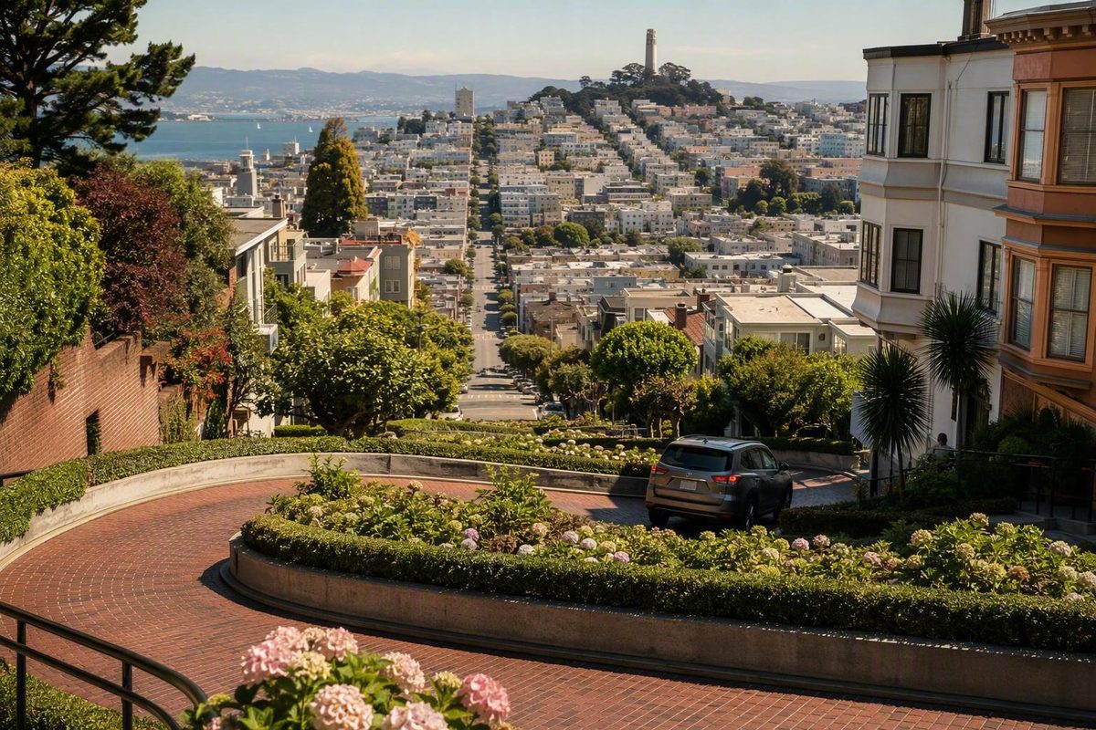
Lombard Street is easy to recognize and surprisingly easy to plan badly. The landmark photographs show a compact ribbon of red brick and tight turns, but the name belongs to a much longer San Francisco street. A map search for “Lombard Street CA” can therefore lead to the wrong section, while a seemingly short walk from the waterfront can become a strenuous climb.
The simplest approach is to treat the crooked block as a brief stop within a larger San Francisco day. Decide whether you want to arrive at the upper Hyde Street end or the lower Leavenworth Street end, account for the hill, and choose walking or driving according to the experience you value most.
Start Here: The Famous Landmark Is Only One Block
Lombard Street is in San Francisco, California, and its famous crooked block is in the Russian Hill neighborhood. Although the street extends across much of northern San Francisco, the landmark section occupies only the block between Hyde Street and Leavenworth Street. Hyde is the upper, western end; Leavenworth is the lower, eastern end. The block has eight hairpin turns, and published visitor guidance describes vehicle traffic as one way downhill toward Leavenworth Street, according to San Francisco Travel’s Lombard Street guide.
For navigation, the intersections are more useful than a single street number:
- Top of the crooked block: Lombard Street and Hyde Street
- Bottom of the crooked block: Lombard Street and Leavenworth Street
- Published driving direction: Downhill from Hyde toward Leavenworth
- Pedestrian route: Public stairs beside the roadway
- Classic uphill photograph: From the Leavenworth end
Published destination listings use different addresses, including 1070 and 1099 Lombard Street. Those numbers identify particular map pins or approach points; neither should be treated as the one correct destination for every visitor. Choose the intersection that fits your plan: Hyde for the top or Leavenworth for the bottom.
Quick planning snapshot
- Cost: State tourism guidance describes the public street as free to visit and free to drive.
- Layout: One steep landmark block with eight turns.
- Walking: Public stairs run along both sides of the roadway.
- Terrain: The crooked block and many surrounding approaches are steep. These layout, access, and cost details are summarized by Visit California.
- Typical stop: A commercial visitor guide suggests roughly 20 to 30 minutes for looking around and taking photographs under straightforward conditions. Treat that as an estimate, not a guaranteed duration, as explained in its Lombard Street timing guidance.
- Extra time: Allow more time for transit, an uphill approach, parking searches, crowds, or a possible vehicle queue.
- Best role in the day: A short stop paired with Russian Hill, the waterfront, or North Beach.
Do not confuse the sightseeing estimate with total trip time. Transportation, hills, waiting, parking, and the connection to your next destination can take longer than the visit itself.
Current-status limitation — August 13, 2026: The supplied evidence does not verify same-day street access, construction controls, closures, Muni operations, curb-loading rules, parking availability, or temporary traffic restrictions. Operational details below are therefore attributed to published guidance rather than presented as confirmed current conditions. Before leaving, consult current San Francisco city and Muni information. At the block, posted signs, barriers, and staff instructions take precedence over this article.
Why Lombard Street Has Eight Turns—and What Its Nickname Gets Wrong
The switchbacks were not created solely as a decorative tourist attraction. The crooked block was constructed in 1922 to make the steep grade more manageable for vehicles. Rather than requiring drivers to tackle the hill in a straight line, the design redirects them through eight tight turns across a single block. The red-brick roadway became part of the block’s recognizable appearance, but the underlying design answered a practical transportation problem, as summarized in the historical overview of Lombard Street.
That history matters because modern photographs can make the block look like a landscaped installation built for visitors. It remains a residential street lined with occupied homes. The roadway, stairs, landscaping, pedestrians, vehicles, driveways, and residential entrances all occupy a constrained space.
Lombard Street is often called the “Crookedest Street in the World,” but that phrase is a popular nickname rather than a verified record. “Crookedest” has no universally accepted measurement. It might refer to the number or sharpness of turns, the amount of horizontal deviation, the slope, or the relationship between road length and straight-line distance.
Vermont Street in Potrero Hill is frequently offered as a more crooked San Francisco street under measures such as sinuosity. That does not produce an absolute winner; it means the result depends on the criterion. A local comparison of Lombard and Vermont streets identifies Vermont Street as more crooked under its chosen measure, while Lombard remains the more visually prominent landmark.
You may also encounter descriptions of the hill as either 27 degrees or a 27 percent grade. Those units are not interchangeable, and the supplied sources use them inconsistently. It is more accurate—and more useful for planning—to describe the block as very steep than to repeat a disputed measurement.
The supported history is straightforward: a difficult hill led to a switchback design in 1922; the resulting one-block road contains eight turns and red-brick paving; and its appearance became internationally recognizable. Celebrity stories, supernatural anecdotes, and unsupported visitor totals are unnecessary to explain why the block matters.
Choose Your Starting Point: Hyde Street or Leavenworth Street
There is no universally best starting point. Hyde and Leavenworth suit different arrival methods, viewpoints, and levels of physical effort.
Start at Hyde Street if you want to walk downhill
Hyde Street is the upper end of the crooked block. Published tourism guidance identifies it as the convenient starting point for passengers using the Powell–Hyde cable car and for visitors who prefer to descend the pedestrian stairs rather than climb them.
A simple top-to-bottom sequence is:
- Arrive near Hyde and Lombard.
- Pause in an appropriate public area near the top to understand the layout.
- Descend using one of the public side stairways.
- Stop only where you will not block other pedestrians.
- Finish at Leavenworth Street.
- Look back from the lower public area for the familiar uphill view.
This route does not eliminate exertion. Reaching Hyde Street can involve hills unless transit brings you close to the intersection, and descending a steep staircase still requires control and balance. It does, however, avoid climbing the stairs beside the switchbacks.
Start at Leavenworth Street if the classic view matters most
Leavenworth Street is the lower end and the familiar position for looking uphill at the complete switchback pattern. If your priority is one recognizable overview rather than walking the entire block, this may be the more direct endpoint.
The tradeoff is elevation. Starting at Leavenworth and continuing to Hyde requires climbing the steep side stairs. Visitors approaching from North Beach or the Fisherman’s Wharf side may naturally arrive from lower elevations, but a short map distance does not mean the final approach will feel gentle.
A reverse route works like this:
- Approach Leavenworth and Lombard from the east or waterfront side.
- Take the uphill photograph from an appropriate public position.
- Climb the public stairs only if your mobility, footwear, and energy permit.
- Finish at Hyde Street.
- Confirm a suitable current transit or downhill departure option instead of automatically retracing the climb.
This version can fit an east-to-west itinerary, but it is the more demanding walking sequence. If you mainly want the lower view, there is no obligation to climb to the top and return.
Whichever direction you choose, remain on public stairs and sidewalks. Gardens, private entrance steps, garage aprons, and driveways are not alternative viewing platforms. A less dramatic photograph is better than intruding on a home or forcing someone around you.
Getting There Without a Car
For many visitors, transit can remove the need to search for scarce nearby parking. It should not be assumed to be faster, however: service changes, waits, crowds, and transfers can alter the trip.
The routes below are published planning options, not confirmation of current Muni service. Verify the line, stop, fare, accessibility, and operating status through current official Muni information before departure.
Powell–Hyde cable car: published access to the upper entrance
Tourism sources consistently identify the Powell–Hyde cable car as stopping near Hyde and Lombard at the top of the crooked block. If current service confirms that option for your travel date, it supports a coherent top-to-bottom plan:
- Ride to Hyde and Lombard.
- Visit the upper viewpoint.
- Descend the public stairs.
- Take the lower photograph at Leavenworth.
- Continue east or downhill rather than immediately returning to the top.
Avoid scheduling a tight connection immediately after the visit.
Powell–Mason cable car: an additional walk
Published guidance places the Powell–Mason line around Lombard Street and Columbus Avenue, leaving a walk of several blocks toward the crooked section. The distance may appear minor on a map, but the approach includes elevation gain.
This option makes more sense if Columbus Avenue, North Beach, or another stop along that route already fits your day. It is less suitable if your main goal is minimizing uphill walking.
The 30 bus: a published Columbus Avenue alternative
Tourism guidance also identifies the 30 bus as an option from Union Square to Columbus Avenue near Lombard Street, followed by an uphill walk. The Powell–Hyde, Powell–Mason, and route 30 options appear together in Visit California’s transportation guidance cited above.
Use a Columbus Avenue option only after confirming current service and deciding that the uphill finish is manageable. In San Francisco, direction and elevation can matter more than block count.
Walking from the waterfront or North Beach
Walking can be practical from Fisherman’s Wharf, Ghirardelli Square, or North Beach, but inspect the terrain rather than relying only on distance. Routes toward Russian Hill can become steep near the attraction.
Before choosing to walk, ask:
- Am I comfortable with a sustained uphill approach?
- Do I also intend to climb the stairs beside the crooked block?
- Can I depart in another direction rather than repeating the climb?
If the first two answers are uncertain, investigate transit for the uphill portion and walk downhill afterward.
Rideshare and taxi planning
The supplied evidence does not verify a designated loading point at either end of the block. Request pickup or drop-off only where stopping is lawful and will not obstruct traffic, sidewalks, driveways, garages, or residential entrances.
Do not assume that an app-generated pin is a legal or safe stopping place. If the suggested location is unsuitable, communicate with the driver and move to a lawful position away from the constrained block.
A mode-based decision is usually enough:
- Investigate Powell–Hyde if you want to reach the top and descend.
- Investigate Columbus Avenue transit if it fits your route and you accept an uphill walk.
- Walk from nearby districts only if you are comfortable with hills.
- Use a taxi or rideshare only after identifying a lawful, non-obstructive stopping location.
Driving the Crooked Block: Direction, Cost, Queues, and Parking
Published state and city tourism guidance describes the crooked block as open to vehicles traveling one way downhill, or eastbound, from Hyde Street toward Leavenworth Street. The same guidance describes visiting and driving the public street as free. Because the evidence pack does not include a same-day municipal operating notice, confirm current access before treating either statement as current policy.
Temporary closures, emergency controls, construction, special events, or later traffic-management rules could supersede the normal arrangement described by those sources. Follow posted controls and traffic personnel when you arrive.
What happened to the proposed reservation and fee?
Reports of a Lombard Street driving reservation arose from a real but historical proposal. The San Francisco County Transportation Authority completed a paid vehicle-reservation design in 2019. State legislation that would have authorized the program was vetoed that October. In 2020, the agency reported that it was pursuing authority for a no-fee reservation concept. The SFCTA project timeline does not establish that either proposal became an operating visitor system.
That record does not prove that Lombard Street can never have a reservation, fee, closure, or other access restriction. It shows only that the documented paid program was proposed rather than implemented under the cited legislation. Verify present requirements instead of relying on old headlines about a future toll.
What driving actually adds
Driving provides an experience that walking cannot: sitting behind the wheel or riding in a vehicle as it follows the switchbacks. If that sensation matters to you, driving may be worthwhile.
It also introduces uncertainty:
- A vehicle queue may form during busy periods.
- Nearby parking is described as scarce.
- The street must accommodate residential access as well as visitors.
- Drivers have little opportunity to pause and study the view.
- Exiting at Leavenworth does not solve where to park or what to do next.
Do not plan around a specific queue time. Demand, weather, temporary controls, and neighborhood conditions can change the wait. Likewise, do not rely on an unverified nearby garage or assumed curb space.
Several visitor guides report a 5 mph restriction or recommendation, but the supplied evidence does not verify the current legal control through a same-day municipal source. One such report appears in the local Lombard Street guide linked earlier. Whatever a guide says, current posted signs and instructions govern. Drive slowly enough for conditions, remain prepared to stop, and treat the block as an active residential street rather than a novelty course.
The supplied sources also conflict over the precise required approach to the entrance, including whether a direct turn from Hyde Street is allowed. Do not rely on a generalized turn instruction from a travel article. Follow current signs, lawful navigation directions, barriers, and instructions from traffic personnel.
Walking versus driving
Consider driving if:
- Experiencing the switchbacks from inside a vehicle is a priority.
- You accept the possibility of a queue.
- You already have a practical vehicle and parking plan elsewhere.
- Current official information confirms vehicle access.
Consider walking if:
- You want more time to observe and photograph the block.
- You would rather avoid joining a vehicle queue.
- You can reach an endpoint by a confirmed transit or walking route.
- You can manage the stairs and steep approaches.
Walking is not automatically effortless, and driving is not automatically convenient. The better choice depends on whether you are trying to minimize physical exertion, parking uncertainty, or time in traffic.
Photos, Crowds, and a Realistic Visit Length
The established lower viewpoint is at Leavenworth Street, where visitors can look uphill at the switchback pattern. Hyde Street offers a perspective from above, while the public side stairs provide closer views of the turns and brick roadway.
None is objectively best. The lower endpoint emphasizes the complete zigzag, the top helps explain the elevation change, and the stairs provide detail. Choose the perspective that fits your route instead of repeatedly climbing the block to collect every possible angle.
A commercial guide suggests allowing roughly 20 to 30 minutes to see the block and take photographs. Its photo guidance identifies Hyde, Leavenworth, and the side stairs as different perspectives. This is a planning estimate rather than an official or guaranteed visit time.
The estimate excludes:
- Travel to and from Russian Hill
- Cable-car or bus waits
- Parking searches
- Vehicle queues
- A slower stair pace
- Rest breaks
- Heavy pedestrian crowding
- Connections to another neighborhood
A weekday or another off-peak period is a reasonable crowd-avoidance strategy, but the supplied evidence contains no recent official crowd data establishing a universally quiet hour. Holidays, events, school schedules, weather, tour groups, and seasonal travel patterns can override generic advice.
There is also no universally ideal light. Buildings, fog, cloud cover, season, and your viewing direction can change the scene. Work with the conditions you find rather than entering private space to improve the composition.
Responsible photography checklist
- Stay out of the vehicle lane.
- Use public sidewalks, stairs, and endpoint areas.
- Keep stair and sidewalk traffic moving.
- Step aside before taking an extended photograph.
- Leave driveways and garage entrances clear.
- Do not pose in flowerbeds or other landscaping.
- Do not use private doorways, steps, or walls as backdrops.
- Keep tripods and other equipment from narrowing the walkway.
- Never ask a driver to stop within the crooked block for a photograph.
Lombard Street becomes more worthwhile when it is part of a broader route. As a stand-alone destination, it is one steep block. As the transition between a cable-car ride, Russian Hill, North Beach, and the waterfront, it can become a memorable part of an efficient day.
Steep Terrain, Safety, and Residential Etiquette
The crooked block and its surrounding approaches are steep. Pedestrians generally experience the attraction from the public stairs beside the roadway rather than by walking in the vehicle lane.
Do not characterize the route as easy, stroller-friendly, wheelchair-accessible, or suitable for every visitor with limited mobility. The evidence pack does not document a verified step-free route through the attraction. It also does not establish a current accessible parking space, legal loading zone, rest point, or accessible public restroom at the block.
A lower-exertion view may be possible from an appropriate public endpoint or from inside a vehicle, but the evidence does not confirm that either option provides dependable step-free access or a lawful place to stop. Investigate current curb, loading, traffic, and viewpoint conditions before relying on such a plan. Travel reporting also describes the surrounding walk as physically demanding, reinforcing the need for advance terrain planning in TravelAwaits’ account of visiting Lombard Street.
Visitors who use the stairs should:
- Wear footwear suitable for a steep urban staircase.
- Move at a controlled pace.
- Let faster pedestrians pass where space permits.
- Keep attention on crossings and roadway edges.
- Stop only where others can move around them.
- Avoid backing toward the street while framing a photograph.
Remaining in public areas is not merely a matter of politeness. This is an occupied residential block, not a closed tourist set. Residents need dependable access to homes, garages, driveways, deliveries, and emergency services.
Resident-respect checklist
- Keep driveways, garage doors, and entrances clear.
- Do not sit or stand on private entrance steps.
- Stay out of gardens and flowerbeds.
- Do not touch plants, gates, signs, or decorations.
- Keep voices, music, and group commentary at a considerate level.
- Do not look through windows.
- Keep photography equipment within public space.
- Carry out drinks, food packaging, and other litter.
- Follow temporary barriers and resident-access instructions.
- Move promptly if your position obstructs a doorway or vehicle.
Pedestrians should remain on sidewalks and stairs and watch for vehicles near crossings. Drivers should expect people near the edges of the block and proceed cautiously. Unsupported accident, theft, or vehicle-break-in statistics are not necessary to justify ordinary care in a constrained space shared by visitors, vehicles, and homes.
Turn a Short Stop Into a Well-Routed San Francisco Day
Lombard Street works better as a transition point than as a full-day attraction. The most efficient itinerary arrives at one elevation, moves through the block once, and continues toward the next destination instead of returning uphill to the starting point.
The compact transit-assisted plan
If current Muni service supports it, a clean first-time route is:
- Take the Powell–Hyde cable car to Hyde and Lombard.
- Look over the block from an appropriate upper public area.
- Descend one of the public side stairways.
- Take the familiar uphill photograph from Leavenworth.
- Continue toward North Beach or the waterfront.
This sequence places transit on the uphill side and walking on the downhill side. It also provides the upper view, stairs, and lower overview without an unnecessary out-and-back climb.
Waterfront extension
For a waterfront-oriented day, continue toward Ghirardelli Square or Fisherman’s Wharf after visiting the crooked block. These places are commonly described as being within walking distance, but the practical effort depends on where you finish, the route chosen, and your comfort with hills.
A useful structure is:
- Confirm transit to Hyde and Lombard.
- Walk down the crooked block.
- Continue downhill toward Ghirardelli Square.
- Extend along the waterfront toward Fisherman’s Wharf if time and energy remain.
- Use transit for the next major connection.
This works particularly well when Lombard Street is a morning or early-afternoon landmark rather than the last stop after a tiring day. Keep moving toward lower ground instead of returning to Russian Hill solely to retrieve a vehicle.
North Beach and Chinatown extension
For a neighborhood-focused day, continue east toward North Beach. Its streets, cafés, and food stops provide a natural next stage after the lower viewpoint.
If time and energy remain, extend toward Chinatown. “Within walking distance” does not mean “physically easy.” Gradients, crossings, navigation, and time already spent on stairs matter more than the straight-line distance displayed on a phone.
An efficient eastward sequence is:
- Start at Hyde Street.
- Descend the crooked block.
- Continue into North Beach.
- Pause for a meal or café.
- Add Chinatown only if the day still feels comfortable.
- Leave by transit rather than reversing the entire route.
Cable Car Museum pairing
The Cable Car Museum is another commonly listed pairing, particularly when the Lombard Street visit already includes a cable-car ride. Do not assume a particular walking time or effortless route. Confirm opening information, inspect the terrain, and investigate transit if the connection would add more climbing than you want.
Use one-direction routing
The central itinerary principle is simple: avoid turning a brief landmark visit into an accidental hill workout.
- Use confirmed transit for the steeper approach where practical.
- Walk through the attraction in one direction.
- Choose the next stop according to where you finish.
- Do not return uphill merely because the original plan assumed a loop.
- Keep a transit fallback for fatigue, weather, or service changes.
This approach reflects San Francisco Know’s stated focus on practical planning around hills, transit, and efficient visitor days. The objective is not to fit every nearby attraction into one outing. It is to create a route that still works when map contours become actual streets.
Frequently Asked Questions
Is Lombard Street in California free to visit?
Published city and state tourism guidance describes Lombard Street as a public street with no admission charge and says driving through the crooked block is free. San Francisco Travel provides the same general cost guidance in its visitor information cited above.
That is not a guarantee against temporary access controls or later policy changes. Check current official conditions before visiting or driving.
Do I need a reservation to drive down Lombard Street?
The historical SFCTA record documents proposed reservation systems, not proof of a currently operating program. A paid proposal was developed in 2019, but the authorizing legislation was vetoed; a no-fee concept was discussed in 2020. The SFCTA status record does not establish that either system was implemented.
Because that timeline is historical rather than a same-day operating notice, verify current requirements before driving.
Can I walk down the crooked part of Lombard Street?
Published visitor guidance says public pedestrian stairs run beside the crooked roadway. Visitors can descend from Hyde Street toward Leavenworth Street or climb in the opposite direction, but the block and surrounding approaches are steep.
Remain on the public stairs and sidewalks rather than walking in the vehicle lane or entering private landscaping.
Is Lombard Street wheelchair accessible or suitable for strollers?
The available evidence does not establish a verified step-free route, accessible loading point, or suitable stroller route through the attraction. It would be unsafe to infer accessibility from the short map distance alone.
Before visiting, investigate current endpoint conditions, lawful loading possibilities, and any vehicle-based option through official local information. Do not assume that a nearby drop-off pin provides usable or legal access.
Is Lombard Street actually the crookedest street in the world?
Not as a settled factual record. “Crookedest Street in the World” is a popular nickname, and the answer changes according to how crookedness is measured. Vermont Street in Potrero Hill is frequently cited as more crooked under some criteria, while Lombard Street remains better known for its eight-turn visual layout.
The final choice is straightforward: use Hyde Street for a transit-assisted downhill visit, use Leavenworth for the classic uphill view, and drive only if the in-car switchback experience matters more than avoiding queues and parking uncertainty. Treat the landmark as a brief residential stop within a larger Russian Hill, waterfront, or North Beach route. Before setting out, verify same-day access and transit information, follow posted controls, and leave the block as quiet and unobstructed as you found it.