
First-visit orientation
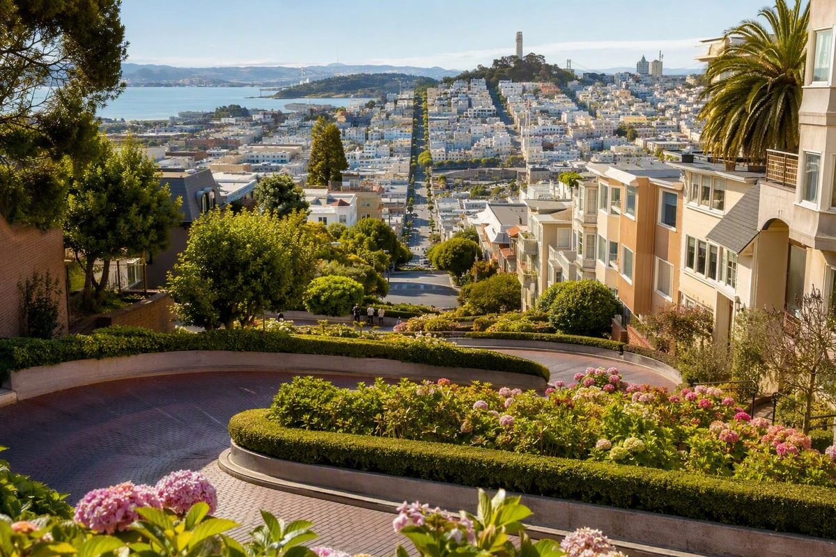
The famous crooked block of Lombard Street is in Russian Hill, between Hyde Street at the upper end and Leavenworth Street at the lower end. Start at Hyde for the broader outlook and a downhill stair walk. Start at Leavenworth for the familiar photograph looking uphill at the curves.
This is an evergreen orientation guide, not confirmation of day-of vehicle access, transit service, stopping rules, or construction conditions. Check current transportation information before leaving and follow posted signs when you arrive.
Start Here: The Crooked Landmark Is Only One Block
Lombard Street extends east–west through northern San Francisco, but the landmark most visitors mean is only the block between Hyde and Leavenworth streets. Searching simply for “Lombard Street” can point you toward an ordinary section of the longer road rather than the Russian Hill curves.
The famous block contains eight sharp switchbacks, red-brick paving, landscaped spaces, side stairs, an active vehicle lane, and occupied private homes. Visitor guides describe vehicles as traveling one way downhill from Hyde toward Leavenworth, although current signs and traffic controls must govern your visit. These basic features are summarized in Visit California’s Lombard Street guide.
Tourism sources describe Lombard Street as a public street with no admission charge. That should not be confused with the cost of reaching it: transit, parking, taxis, ride-hail services, organized tours, and other transportation may involve separate charges. Because the supplied evidence does not include publication-date municipal confirmation of fees, reservations, or vehicle-access rules, verify current conditions rather than treating an older visitor guide as legal or financial authority.
Temporary traffic control, construction, special events, or neighborhood restrictions may also affect your approach. Posted signs and instructions from authorized personnel take precedence over saved maps and travel articles.
Lombard Street quick facts
- Famous block: Hyde Street to Leavenworth Street in Russian Hill
- Upper end: Hyde Street
- Lower end: Leavenworth Street
- Turns: Eight sharp switchbacks
- Reported admission: Visitor guides describe access to the public street as free; transportation and tours may cost extra
- Reported vehicle direction: One way downhill from Hyde toward Leavenworth, subject to current signs
- Pedestrian route: Side stairs and public sidewalks, not the vehicle lane
- Best role in an itinerary: A short sightseeing stop or a connector between Russian Hill, North Beach, and the waterfront
There are several different experiences hidden under the name “Lombard Street.” Someone who wants to descend the stairs should not use the same arrival plan as someone who wants only the classic photograph from below. A visitor interested in driving the curves needs a different plan again. Choose your experience before choosing your route.
Choose Your Arrival: Cable Car, Walking, Transit, or Driving
The easiest way to reach Lombard Street depends on the viewpoint you want, your comfort with steep hills, and your tolerance for waiting or parking uncertainty. A route that looks short on a map may still involve a demanding climb.
| Arrival mode | Where it generally puts you | Hill effort | Likely inconvenience | What you see first |
|---|---|---|---|---|
| Powell–Hyde cable car | Near Hyde and Lombard at the upper end | Reduces the uphill approach, although the site remains steep | Waiting, crowding, or service changes | Upper outlook and the option to descend |
| Powell–Mason cable car | Near Lombard and Columbus | Leaves an uphill approach toward the crooked block | Does not deliver you directly to Hyde | North Beach approach and the lower side of Russian Hill |
| Bus through North Beach | Varies by route and stop | Usually requires some walking and may involve climbing | Routes, stops, fares, and disruptions can change | Lower neighborhood approach |
| Walk from the waterfront | Usually approaches from below or north of Russian Hill | Potentially substantial climbing | Map distance understates elevation | The surrounding neighborhood before the curves |
| Drive the crooked block | Historically approached from Hyde and descended toward Leavenworth | Little walking during the drive itself | Access uncertainty, queues, traffic, and difficult parking | The switchbacks from inside the vehicle |
| Lower-end-only visit | Leavenworth Street | Avoids the landmark stairs if you remain below | Omits the upper outlook | The classic uphill composition |
The table is a planning comparison, not a guarantee of current service, lawful stopping points, or vehicle access. Verify transportation operations shortly before traveling.
Powell–Hyde: the direct cable-car approach
For visitors who want to begin at the top, Powell–Hyde is the most direct cable-car option identified in the supplied sources. It serves Hyde and Lombard near the upper end of the crooked block. From there, you can see the outward view from Russian Hill and then descend beside the switchbacks instead of climbing the landmark block first.
Powell–Mason serves a different purpose. It passes near Lombard Street and Columbus Avenue, leaving an uphill approach toward the crooked block rather than delivering visitors directly to Hyde. That can suit a North Beach itinerary, but it should not be confused with the top-of-the-block approach. The relationship between the two lines and Lombard Street is described by San Francisco Travel.
Do not rely on older tourism material for current fares, operating hours, frequency, boarding procedures, stop locations, or transfer rules. Consult SFMTA’s current trip-planning and service-alert information shortly before departure, then review notices at the stop.
Bus and North Beach approaches
The 30 bus appears in tourism material as an approach through North Beach. Treat that as a general geographic suggestion, not confirmation that a particular stop or service pattern will work on your visit date.
Check the current route, stop, fare, schedule, and disruption information through SFMTA before setting out. Even when a bus reaches the surrounding neighborhood, the final approach may still include an uphill walk.
Walking from Fisherman’s Wharf
Fisherman’s Wharf and Lombard Street can look close on a map, but the missing information is elevation. The approach toward Russian Hill can become steep quickly, particularly if you are aiming for Hyde Street at the top.
A personal travel account describes the waterfront approach as short in distance but very steep, illustrating why map distance should not be converted into a guaranteed walking time. Fitness, footwear, luggage, crossings, crowds, and the exact starting point all affect the effort required. The same account also emphasizes that the crooked block remains an operating road, so photographers need to prioritize traffic safety (State by State Travel).
If you want the upper outlook without the climb, use suitable transportation for the ascent and walk downhill afterward. If you want only the lower photograph, approach Leavenworth and decide in person whether the stairs are worth adding.
Driving as a separate experience
The supplied visitor sources describe driving through the curves as possible under a one-way downhill arrangement. They do not provide publication-date municipal confirmation that the same access will be available when you arrive. Check current city information where available and treat posted signs as controlling.
Driving should be considered its own sightseeing choice rather than the default way to reach the landmark. A car allows you to steer through the switchbacks, but it does not necessarily make it easier to stop, take photographs, examine the landscaping, or continue into a walkable neighborhood.
Parking uncertainty can erase the convenience of arriving by car, while a queue can make a very short road the least predictable part of the visit. If your priority is seeing the design, homes, and views, arriving without a car may give you more control. If driving the curves is the goal, keep that experience separate from the questions of where to park and how to explore on foot.
A Simple Two-Viewpoint Walking Plan
For visitors who can comfortably manage steep stairs, the cleanest plan is to start high and finish low:
- Arrive near Hyde and Lombard.
- Pause at the upper end for the broader city and bay perspective.
- Descend on a side stairway, remaining outside the vehicle lane.
- Pause only where space permits without blocking people using the stairs.
- Finish at Leavenworth Street for the familiar view looking uphill through the switchbacks.
- Continue toward your next neighborhood instead of automatically climbing back to Hyde.
The endpoints produce different photographs. The upper end opens the view beyond the block, while the lower end compresses the brick curves, landscaping, vehicles, and homes into the recognizable uphill composition. Neither perspective is objectively better.
Pedestrians should remain on public stairs and sidewalks rather than entering the active vehicle lane. Wait for a safe sightline from a pedestrian area, accept that people or vehicles may appear in the frame, and do not step into the intersection for a centered photograph. Keep clear of private entrances, gardens, steps, and driveways. The side-stair arrangement and the distinction between the upper and lower views are described in this Lombard Street visitor overview.
Choose a visit format
Brief lower-viewpoint stop: plan roughly 15–20 minutes
Use this format if you are already near North Beach or the waterfront, have limited time, or do not want to use the stairs. Approach the Leavenworth end, view the curves from below, take a few photographs from a public pedestrian position, and continue with your day.
This is a planning allowance, not a measured average. It works best as a single-viewpoint stop and avoids creating a climb simply to return to the same place.
Standard downhill visit: plan roughly 30–60 minutes
Arrive near Hyde, see the upper perspective, descend beside the curves, and finish with photographs from Leavenworth. A visitor guide estimates 30–60 minutes for exploring the crooked block, but the range should be treated as a flexible scenario rather than a guaranteed duration.
Extended visit
Stay longer only if you want to study the architecture, wait for changing photographic sightlines, explore nearby public streets, or take frequent rests. The block itself does not need to occupy half a day.
Traveler reports vary from very short stops to much longer visits, reflecting different arrival points, crowds, walking speeds, and photography habits. The variation in Tripadvisor’s visitor reports supports flexibility, not a single “typical” duration.
Remember that descending changes your elevation. If your car, hotel route, or next transit connection requires you to return to Hyde, your plan includes a steep climb back up. A one-direction itinerary avoids that hidden penalty.
Driving the Curves: Direction, Queues, and Trade-Offs
The supplied sources describe the crooked block as carrying one-way downhill vehicle traffic from Hyde toward Leavenworth. Because current access has not been verified through a publication-date municipal source, do not treat that historical or tourism-source description as a guarantee. Follow current signs and any temporary traffic controls.
Approach the block as an operating residential road, not as a ride or closed tourist course. Residents need access to their homes, pedestrians use the side stairs and crossings, and drivers may be concentrating on unfamiliar turns.
Driving provides the physical experience of steering through the switchbacks. The trade-off is that the driver’s attention must remain on the road. Passengers can look around more freely, but walkers generally have more time to observe the brickwork, landscaping, homes, and outward views.
Parking can be difficult, and historical transportation studies documented periods when demand produced queues. Those older findings cannot predict conditions on a particular day.
Historical context—not a description of current conditions
A San Francisco County Transportation Authority draft memorandum published in September 2016 reviewed earlier studies and management efforts. It found that historical peak vehicle demand could approach or exceed the crooked block’s capacity. A four-weekend closure pilot in 2014 reduced queues and pedestrian conflicts during closure periods but shifted some traffic and parking pressure to nearby streets or other times.
The memorandum also discussed enforcement, parking changes, closures, gates, access restrictions, transit options, and congestion pricing. These were management options under study—not evidence that any proposal became current policy. Dates, findings, and limitations appear in the Transportation Authority’s draft Lombard Street study.
The supplied evidence does not establish a current reservation system, driving toll, or access fee. That absence of evidence is not proof that arrangements can never change. Confirm current rules before entering.
If vehicle access is permitted when you arrive:
- Enter only from the approach allowed by current signs.
- Follow traffic controls and instructions from authorized personnel.
- Drive slowly and watch for pedestrians near crossings and curbs.
- Do not stop in the active lane for photographs.
- Do not allow passengers to enter or leave the vehicle in an unsafe or prohibited location.
- Keep driveways, gates, and resident access clear.
- Avoid repeatedly circling residential blocks while searching for parking or a photograph.
- Let a passenger handle navigation so the driver can concentrate on the road.
If driving the turns is not a specific goal, transit followed by a downhill stair walk may provide a more flexible visit. It also separates sightseeing from the uncertain question of where to leave a car.
Steepness, Stairs, and Mobility Limitations
The crooked block is steep, as are several common approaches. Pedestrian stairs run beside the roadway, making the elevation change explicit even though the switchbacks reduce the effective steepness experienced by vehicles.
The natural hill has been reported as a 27 percent grade. Percent grade compares vertical rise with horizontal distance; it is not the same measurement as a 27-degree angle. The reported grade and the history of the switchback design are summarized in the collaboratively edited Lombard Street history.
The supplied evidence does not establish any of the following:
- A dependable step-free route
- A verified wheelchair-accessible viewpoint
- A stroller-friendly path
- A lawful accessible drop-off point beside the block
- Current nearby accessible parking
- A consistently unobstructed curb or loading area
Do not build a mobility-sensitive plan around those assumptions. Visitors with specific requirements should check current curb, slope, construction, transit, paratransit, and legal stopping conditions through the relevant city and transportation channels before traveling.
Someone who cannot use steep stairs may prefer a single-end visit:
- Leavenworth concept: Remain near the lower end and view the curves looking uphill.
- Hyde concept: Arrange suitable transportation to the upper area and see the outward view without committing to the descent.
- Passenger concept: If current vehicle access permits, experience the turns from a vehicle while arranging safe and lawful boarding elsewhere.
The Leavenworth option is only a planning concept, not a verified accessible route. Reaching the lower end may still involve sloped streets, curbs, crowds, construction, and uncertain stopping conditions. “Bottom” does not necessarily mean flat or step-free.
Waterfront proximity likewise does not guarantee an easy walk. If exertion is a concern, use transportation for the uphill portion and reserve walking for a section whose conditions you have confirmed.
Family guidance must remain conditional. Steep stairs, an active road, crossings, and distracted sightseers require close supervision of children. The evidence does not establish that the route is universally suitable for children or strollers.
Wear secure footwear, descend at a controlled pace, and use handrails where available. Allow faster pedestrians to pass without stepping toward the roadway.
Why Lombard Street Has Eight Switchbacks
The curves were not originally created as a tourist spectacle. They were a practical response to a difficult hill.
The switchback design was introduced in 1922 after property owner Carl Henry proposed it. Replacing a direct descent with a series of turns reduced the effective steepness experienced by automobiles and made the route more manageable. The date, attribution, and purpose are documented in the same Lombard Street historical overview.
That origin explains the block’s structure. Its eight turns repeatedly redirect vehicles across the slope instead of sending them straight downhill. Red-brick paving makes the route visually distinct, and planted spaces occupy the areas formed between the bends. Homes line both sides, while stairs provide a separate pedestrian route.
The compact geometry creates a memorable image: a short succession of curves enclosed by landscaping and residences, with wider city views opening beyond the block.
The broader street has its own history. Lombard Street was named after Lombard Street in Philadelphia. That detail is secondary to planning a visit, but it reinforces an important distinction: the name belongs to a much longer street, while the tourist landmark occupies one engineered block.
Current visitor totals are unnecessary for understanding the site. Older estimates should not be presented as present-day counts. What matters for planning is that this remains a compact residential street used by sightseers, residents, pedestrians, and vehicles.
Is It Really the Crookedest Street in the World?
“The crookedest street in the world” is a nickname, not a settled factual title.
Any ranking requires a definition of “crooked.” Possible criteria include:
- Total number of turns
- Number of turns within a fixed distance
- Tightness of individual curves
- Overall change in direction
- Natural or effective grade
- Road length
- Curve density
- Whether the route is continuously drivable
Different criteria can produce different answers. A road with more turns is not necessarily steeper, and a shorter road may pack its curves more tightly.
Vermont Street in Potrero Hill is commonly raised as a San Francisco alternative. Some descriptions characterize it as steeper or more crooked under a different interpretation. One comparison gives Vermont Street seven turns, while Lombard has eight, demonstrating why turn count alone does not settle the question. San Francisco Travel discusses both the eight-turn Lombard block and Vermont Street as a competing claim, without supplying a universal quantitative standard.
It would therefore be misleading to declare either street definitively more crooked. Lombard’s fame is easier to explain without relying on a superlative: it combines compact switchbacks, brick paving, landscaping, occupied homes, steep side stairs, outward views, and a location in a heavily visited part of northern San Francisco.
Visit for the relationship between the street and the hill—not to resolve a global road-ranking contest.
Fit Lombard Street Into a Hill-Smart San Francisco Day
Lombard Street works best as a short anchor or connector. It rarely needs half a day by itself, and forcing it into a round trip over Russian Hill can consume more energy than the stop requires.
Geographically compatible areas include:
- Fisherman’s Wharf
- Ghirardelli Square
- North Beach
- Chinatown
- Coit Tower
- PIER 39
These places are close enough to combine conceptually, but “nearby” does not mean “flat.” Compare elevation and direction as carefully as map distance.
Downhill-oriented example
Use this sequence if you want the complete walking experience:
- Reach Hyde and Lombard by cable car or another suitable transportation option.
- See the upper outlook.
- Descend using a side stairway.
- Take the uphill photograph from the Leavenworth end.
- Continue generally toward North Beach or the waterfront.
- Use transit later rather than immediately climbing back to Hyde solely to recover your starting point.
This plan turns Lombard Street into a transition from higher Russian Hill toward lower destinations. It also avoids finishing at Leavenworth only to discover that your next commitment is back above Hyde.
North Beach can lead into Chinatown, while a waterfront direction can connect with Fisherman’s Wharf, Ghirardelli Square, or PIER 39. Coit Tower may fit geographically, but it introduces another elevation decision. Do not add it simply because the map distance looks manageable.
Lower-end example
If you are already in North Beach or near Fisherman’s Wharf:
- Approach the Leavenworth end.
- View the switchbacks uphill.
- Take photographs from a public pedestrian area.
- Look at the stairs and assess your group’s energy.
- Climb only if the upper view and full walking experience justify the effort.
- Otherwise, continue with the lower part of your itinerary.
This keeps a brief landmark stop genuinely brief. It is particularly useful when Lombard Street is one item among several or when members of your group have different levels of interest in climbing.
Leave slack in the schedule
Avoid placing a tightly timed reservation or transportation connection immediately after Lombard Street. Your visit may be affected by:
- Transit waits or disruptions
- A slower climb or descent than expected
- Crowding at a viewpoint
- Time spent waiting for a safe photograph
- Traffic near the block
- The pace of children or less-mobile companions
- A decision to continue into a nearby neighborhood
These variables do not require reserving hours for the street. They simply argue for a flexible buffer rather than a minute-by-minute plan.
If your larger day includes the Marina, Crissy Field, or the Golden Gate Bridge, treat that as a separate outing rather than implying that Lombard Street lies directly on the same route. A self-guided Golden Gate waterfront walk can help organize that distinct waterfront segment.
Visit like someone’s home is beside you—because it is
Before leaving, check that your visit has respected both the road and the neighborhood:
- Stay on public stairs, sidewalks, and viewing areas.
- Keep driveways, gates, entrances, and stairways clear.
- Do not enter private gardens, porches, steps, or walls for photographs.
- Keep voices, music, and vehicle noise down.
- Carry out litter.
- Supervise children near stairs, curbs, crossings, and moving vehicles.
- Cross only when it is safe and permitted.
- Never stop a vehicle in an active lane for a photograph.
- Do not treat residents or their homes as props.
- Follow current signs even when they differ from saved directions.
A successful visit is not measured by how long you stay. It is measured by whether you see the perspective you wanted, avoid unnecessary climbing, and leave without obstructing the people who live or travel there.
Frequently Asked Questions
Is Lombard Street free to visit or drive?
The supplied tourism guides describe the crooked block as a public street with no admission charge and report that driving it does not carry a separate attraction fee. Visit California states that the street is free to walk or drive in its visitor guidance.
That is not publication-date municipal confirmation of current vehicle access, reservations, tolls, or temporary controls. Transportation, parking, tours, taxis, and transit may cost extra. Verify current conditions and obey posted signs.
Which cable car goes to the top of Lombard Street?
The Powell–Hyde cable car is the direct line identified by the supplied sources for reaching Hyde and Lombard near the upper end. Powell–Mason passes near Lombard and Columbus but leaves an uphill approach toward the crooked block.
Verify current routes, stops, fares, schedules, and disruptions through SFMTA before traveling. Older tourism guides should not be used as authority for present-day operating details.
How long should I allow for Lombard Street?
Plan roughly 15–20 minutes for a brief lower-viewpoint stop or 30–60 minutes for the upper outlook, stair descent, and photographs from below.
These are itinerary scenarios, not guaranteed or statistically typical visit times. Add time for transit waits, a slower pace on stairs, surrounding streets, or photography. The block alone generally does not need to fill half a day.
Can visitors walk down the crooked part of Lombard Street?
Visitor sources describe public side stairs and sidewalks beside the crooked roadway. Pedestrians should use those routes rather than the active vehicle lane.
Starting at Hyde and descending toward Leavenworth provides both endpoint perspectives, but it also changes your elevation. Returning to Hyde afterward adds a steep climb, so decide where you are going next before starting down.
Is Lombard Street actually the world’s crookedest street?
No authoritative ranking in the supplied evidence establishes that title. “Crookedest” could refer to turn count, steepness, curve density, road length, or another measurement.
Vermont Street in Potrero Hill is often proposed as a local rival, but the evidence provides no shared quantitative standard that definitively ranks the two streets. Lombard Street’s significance does not depend on winning the title.
For the simplest first visit, decide whether you want the upper panorama, lower uphill photograph, stair descent, or drive-through experience. Arrive at the endpoint that supports that goal, check current transportation and access information, follow posted signs, and continue in one direction toward a nearby neighborhood instead of creating an avoidable return climb. Lombard Street is famous, but it remains an active road and residential block; the best visit is brief, safe, flexible, and considerate.