
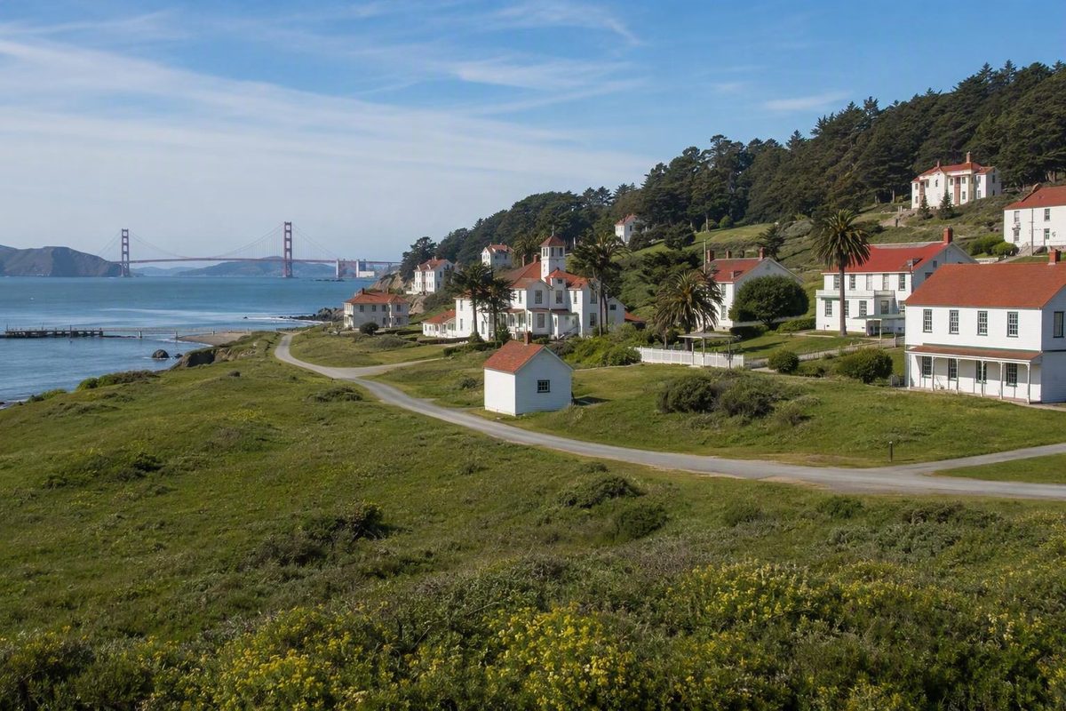
The history of the Presidio of San Francisco is visible in layers. Long before a European fort stood at the Golden Gate, the land was part of the homeland of the Yelamu, a local tribe of the Ramaytush Ohlone peoples. Spain established a fortified outpost there, Mexico later governed it, and the United States Army developed it into a large military installation. After the Army departed, the former post became part of the national park system.
This is necessarily a high-level institutional and landscape history rather than a complete social history. Available sources document military construction, government transitions, preservation, and park management far more fully than they document Yelamu experiences, colonial harms, civilian labor, family life, diverse military units, or late-Cold War operations. Those gaps matter, particularly because the Presidio’s story did not begin with the military institution that supplied most of the surviving records.
The site is best understood not as a park that simply replaced a fort, but as a changing cultural landscape. Adobe remnants, archaeological deposits, barracks, defensive works, roads, a planted forest, a former airfield, medical sites, restored open spaces, and new public landscapes all show how successive authorities reshaped the same ground.
The Presidio at a Glance: A Timeline of Changing Authority and Purpose
The essential chronology can be organized into several broad phases:
| Date or period | What changed |
|---|---|
| Before European colonization to the present; 1776 | The land was and remains part of the traditional territory of the Yelamu, a local tribe of the Ramaytush Ohlone peoples. Spain established the Presidio in 1776 to guard San Francisco Bay and protect Mission San Francisco de Asís. Presidio history overview |
| 1821–1848 | Mexico achieved independence in 1821. A Presidio institutional history dates Mexican operation of the post from 1822. U.S. forces occupied it during the Mexican-American War, while formal U.S. sovereignty followed in 1848. Brief history of the Presidio |
| 1861–1936 | The Army enlarged the post, established Letterman General Hospital, responded to the 1906 disaster, and later operated Crissy Field as an aviation and coast-defense station. EBSCO historical overview |
| 1962 | The Presidio became a National Historic Landmark District, recognizing the significance of its combined buildings, structures, archaeological resources, roads, objects, and landscape features. Archive of Presidio historical documents |
| 1972–1994 | Legislation creating Golden Gate National Recreation Area anticipated the Presidio’s inclusion if the Army left. The Department of Defense selected the post for closure in 1989, and the transfer into the national park system occurred on October 1, 1994. Presidio transition overview |
| 1996–1998 | Congress created the Presidio Trust in 1996. The Trust began operations in 1998 as part of a collaborative management system. Presidio preservation timeline |
| 2001–2022 | Crissy Field’s restored open spaces were unveiled in 2001, the Officers’ Club reopened in 2014, the visitor center opened in 2017, and the 14-acre Presidio Tunnel Tops opened in 2022. Modern Presidio park projects |
The apparently competing dates 1821 and 1822 describe different milestones. The first marks Mexican independence from Spain. The second is used by a Presidio institutional account for the beginning of local operation under Mexico.
The dates 1846, 1847, and 1848 likewise should not be treated as interchangeable. One institutional timeline uses 1847 for Army occupation and initial post use. The year 1848 marks the broader change in sovereignty after the Mexican-American War. These are stages in a transition, not three versions of one event.
Legal status also requires precise wording. The Presidio is a site within Golden Gate National Recreation Area, which is part of the national park system. It is not a legally separate national park unit. It is also a National Historic Landmark District. The recreation-area status defines its place in the park system; the landmark designation recognizes its national historical significance.
Before the Fort: Yelamu Homeland and Continuing Ohlone Presence
The Presidio’s history does not begin with the Spanish fort.
The land at the Golden Gate was and remains within the traditional territory of the Yelamu, a local tribe of the Ramaytush Ohlone peoples of the San Francisco Peninsula. That community-specific description is more accurate than referring only to unnamed “first inhabitants,” and it avoids implying that Indigenous relationships to the land ended when Spain arrived.
A secondary historical overview reports archaeological evidence placing Ohlone people at the Presidio site by at least 740 C.E. That date is best understood as a cautious archaeological marker, not as the beginning of a complete settlement chronology. It does not by itself explain residence, movement, trade, land care, political relationships, or community change over the centuries. The EBSCO reference article provides the archaeological date.
The establishment of a Spanish presidio was therefore not the beginning of human history at the site. It was the imposition of a colonial military institution within an existing homeland.
A fuller account would need Indigenous-authored and specialist scholarship addressing missionization, introduced disease, forced labor, displacement, survival, and community responses to colonial rule. General park histories do not provide enough detail to narrate those experiences responsibly. Their limited coverage should be recognized as a weakness in the surviving institutional narrative, not as evidence that the consequences were limited.
Archaeology broadens the record beyond official correspondence and military timelines. The Presidio manages more than 30 archaeological areas and collections exceeding one million objects and associated records. These materials can document construction, foodways, work, trade, domestic life, and changing land use, including activities that written government records mention only briefly or omit altogether.
Visitors should therefore look beyond monuments and named buildings. Adobe layers, former watersheds, archaeological sites, and apparently open ground can all carry historical meaning. The landscape itself is part of the archive.
The most accurate summary is not that Indigenous people lived there and then disappeared when Spain arrived. The Presidio occupies an enduring Yelamu homeland that was subsequently transformed by colonial and military power.
1776–1848: Spanish Fort, Mexican Outpost, and U.S. Occupation
In this setting, a presidio was a Spanish fortified military outpost. Spain established the San Francisco post to guard the bay against rival European powers and protect nearby Mission San Francisco de Asís.
A secondary general reference identifies Juan Bautista de Anza as the person who selected the site and José Joaquín Moraga as the leader of the party that built the fort later that year. It also associates surviving fabric in the Officers’ Club with the early settlement, including adobe layers dated to the 1790s. General reference overview of the Presidio
Early construction was modest compared with the later Army landscape. Earth, timber, and adobe defined the settlement rather than the extensive barracks, roads, and formal grounds visible in subsequent periods. The Officers’ Club is the most tangible surviving connection, but it should not be read as an untouched Spanish building. Later occupants repeatedly enlarged and altered it. Its historical value comes partly from the survival of early material within centuries of change.
Mexican independence transferred sovereignty away from Spain. Local administration did not necessarily change everywhere on the same day, which explains the use of one date for independence and another for operation of the Presidio under the new government.
Some secondary histories characterize the Mexican-period post as neglected or nearly abandoned. That description may refer to its physical condition or reduced garrison, but it cannot stand as a complete history of the period. A deteriorating fort could still occupy important land and remain connected to soldiers, families, workers, Indigenous communities, and regional political networks. The available summaries do not reconstruct that social world in sufficient detail.
During the Mexican-American War, U.S. forces occupied the Presidio. A secondary account dates the raising of the American flag there to July 9, 1846, while other timelines emphasize subsequent Army occupation and initial use. Formal sovereignty came later. The chronology is therefore best understood as military possession followed by developing Army use and then a broader legal settlement.
Archaeology and building analysis are especially important for this era because later Army construction transformed the central post. Early adobe survives within altered buildings, while buried deposits can reveal layouts and activities that later construction obscured.
Changes among Spanish, Mexican, and American flags still do not provide a complete account of the people affected by those governments. In particular, the effects of colonization on Yelamu communities require Indigenous-authored work and specialized scholarship beyond an institutional chronology.
1848–1906: Building a Major Pacific Coast Army Post
After formal U.S. sovereignty, the Army transformed the Presidio from a small inherited fortification into a much larger military post associated with coastal defense and military operations in the West and across the Pacific.
The post did not appear all at once. It accumulated buildings, roads, utilities, defensive works, and specialized areas through successive construction campaigns. Its built environment eventually included:
- officers’ quarters;
- enlisted barracks;
- headquarters and administrative buildings;
- warehouses and supply facilities;
- stables;
- medical buildings;
- road corridors;
- coastal defenses.
These resources functioned as a connected military landscape. Barracks made more sense in relation to parade grounds, administrative buildings, roads, and quarters than they did as isolated pieces of architecture. Surviving streetscapes reveal the organization and scale of the post more effectively than any single famous building.
That collective character is central to the landmark district. Its significance rests on a combination of sites, buildings, structures, objects, archaeological resources, roads, and landscape features. Published building totals vary because inventories count different categories and come from different dates, so a single number would create misleading precision. The independent Presidio archive describes the district’s landscape-based significance.
The trees were part of a deliberate remaking of the military environment, not simply a natural backdrop around the buildings. The resulting forest is both a living ecological system and a cultural resource created during the Army period.
Letterman General Hospital made military medicine one of the Presidio’s defining functions. Although later redevelopment changed the hospital area, its history remains essential to understanding the former post as more than a collection of barracks and gun positions.
The Presidio also served as a base for troops sent to the Philippines during the Spanish-American War and Philippine-American War. That activity connected San Francisco to the projection of U.S. military power across the Pacific. Assembly, supply, departure, medical care, and return were parts of imperial warfare, not merely neutral logistical processes.
By the beginning of the 20th century, the Presidio had become a military community with housing, administration, transportation, medicine, logistics, defenses, and a deliberately altered landscape. That system shaped its response to the disaster that struck San Francisco in 1906.
1906–1945: Disaster Relief, Aviation, Medicine, and West Coast Defense
Military land offered space during a catastrophic urban emergency, while Army personnel and facilities became part of the city’s response system.
The response can be understood simultaneously as disaster relief and as an exercise of military authority within a civilian city. The available overview supports that distinction, but not a broad conclusion about the response’s effectiveness, fairness, or consequences. Those questions require a fuller disaster history.
Military technology continued to reshape the reservation. Coastal forts and artillery batteries had been designed to confront threats approaching through the Golden Gate. Aircraft later added a new dimension to observation, communication, and defense.
Crissy Field served as an Army aviation and coast-defense station during the interwar period. Its broad, level ground created a landscape unlike the formal Main Post or the concrete coastal defenses. Although the area is now associated with recreation and waterfront access, its open geometry still helps visitors imagine the former airfield.
The surviving batteries provide more explicit physical evidence of coastal-defense strategy. Their concrete structures, magazines, gun positions, and locations show how planners sought to defend the entrance to San Francisco Bay as weapons and perceived threats changed.
It should be understood as one surviving part of a larger defensive system rather than as an isolated military curiosity. A visitor guide identifies Chamberlin among the Presidio’s surviving coastal batteries.
The Army also permitted access through the reservation during construction of the Golden Gate Bridge. This introduced major civilian transportation infrastructure into an active military landscape. Bridge approaches and later roadway projects would continue to shape circulation through the Presidio long after the Army left.
During World War II, the Presidio housed the headquarters of the Western Defense Command, while Letterman treated personnel returning from the Pacific. Those functions joined command administration and medical care within one installation.
A complete wartime history would extend well beyond headquarters and hospital functions. It would examine contested military policies, diverse military units, civilian labor, and the experiences of nurses, physicians, support workers, soldiers, and families. The general histories used here do not support that fuller account, and dramatic troop or freight totals sometimes repeated in secondary summaries are therefore omitted.
By the end of the war, the Presidio contained multiple generations of land use: early adobe, later Army architecture, a planted forest, concrete batteries, an airfield, medical facilities, bridge approaches, and command buildings. That accumulation was fundamental to its eventual recognition as a historic district.
1945–1994: From Active Post to Base Closure
The Presidio’s strategic importance declined after World War II, although it remained an active Army installation for decades. The documentary overview available here does not support a command-by-command account of its late-Cold War operations, so the period is best understood through its major preservation and governmental milestones.
National Historic Landmark District designation recognized that the Presidio’s importance did not rest on a single structure or event. It lay in the combined significance of buildings, defenses, roads, archaeological resources, objects, and designed or altered landscapes.
Congress later created Golden Gate National Recreation Area and provided for the Presidio to join it if the Army departed. The prospect of preserving the post in the national park system therefore preceded the closure decision.
When the Department of Defense selected the Presidio for closure through the base realignment and closure process, the decision created a practical problem as well as a preservation opportunity. A large military installation contained aging buildings, utilities, roads, housing, environmental concerns, and extensive landscapes. Converting it to public use would require long-term management and substantial investment. Debate included the possibility that the property could be sold rather than retained as public land.
The transition involved far more than changing signs and opening gates. Military posts are organized around command, restricted access, housing, logistics, defense, and work. A public park must also accommodate recreation, interpretation, ecological stewardship, preservation, and broad access.
The Army’s departure ended the active military phase, but it did not complete the conversion. The Presidio entered the national park system as part of Golden Gate National Recreation Area, leaving years of rehabilitation, environmental work, planning, and reinvestment ahead.
The evidence for this period remains uneven. Landmark designation, park legislation, closure, and transfer are clear. The daily lives of people stationed or employed there, the evolution of postwar operations, and the full strategic and budgetary reasoning behind closure require a more specialized history.
1994 to Today: Preservation, Adaptive Reuse, and the Presidio Trust
Transfer to the national park system did not settle how the Presidio would be managed or financed. Congress created the Presidio Trust, which later began operations as part of a collaborative management model involving the Trust, the National Park Service, and the Golden Gate National Parks Conservancy.
Adaptive reuse became central to the arrangement. Former Army homes, offices, barracks, and other buildings could be rehabilitated and leased, with revenue reinvested in park operations and preservation. This approach helped keep historic buildings occupied while supporting maintenance of the larger landscape.
Sources use different years and definitions when discussing financial self-sufficiency. Rather than selecting one disputed threshold, the more reliable conclusion is that Congress imposed a financial requirement and that income from leased housing and workplaces became essential to covering operations.
Adaptive reuse brings both benefits and continuing questions. Occupied buildings can be maintained, historic fabric repaired, and revenue directed to public services. At the same time, managers must balance building use with public access, historic integrity, ecological priorities, housing, workplaces, and the identity of a national park site. Institutional financial results should not be treated as evidence about affordability, tenant experience, visitor access, or other stakeholder outcomes without separate research.
Modern projects illustrate several different approaches to transformation:
- Crissy Field changed from a former military airfield into a public waterfront landscape.
- The Officers’ Club was rehabilitated while retaining early adobe material and later architectural layers.
- The visitor center created a central orientation point near the Main Post.
- Tunnel Tops constructed a new public landscape above roadway tunnels, reconnecting the historic center of the post with Crissy Field.
Crissy Field and Tunnel Tops are not unchanged military remnants. Crissy Field retains the spatial memory of an airfield, but its modern public use has redefined the area. Tunnel Tops is a deliberately contemporary landscape made possible by roadway reconstruction. Both show that preservation may include transformation rather than an attempt to freeze one historical moment.
Ongoing work also includes archaeological research, collection care, building rehabilitation, habitat restoration, invasive-plant removal, trail improvements, and public interpretation. These activities can reinforce one another, but they can also compete for land, funding, and attention.
The historic forest demonstrates the difficulty of managing a living cultural resource. Trees planted by the Army eventually age and change, creating questions different from those posed by masonry or adobe. Archaeological deposits may coexist with habitat projects. Housing and workplaces can support maintenance while influencing how buildings and land are used.
There is no final condition in which these tensions disappear. The contemporary Presidio remains an experiment in balancing historic resources, ecology, public use, housing, employment, and revenue.
Reading the Landscape: What the Presidio’s Surviving Places Reveal
A first visit makes more historical sense when organized as a sequence rather than an exhaustive attractions list:
- begin at the Presidio Visitor Center;
- continue to the Officers’ Club;
- read the Main Post as a complete military district;
- cross Tunnel Tops;
- finish at Crissy Field;
- add the former Letterman area or coastal batteries if time and mobility allow.
This general progression follows the interpretive approach used in Presidio walks that examine changes from the Spanish fort to Tunnel Tops. Current route conditions must still be checked before setting out. A past Parks Conservancy walk illustrates this chronological approach.
Begin at the Presidio Visitor Center. Use it to establish the main historical layers: Yelamu homeland, Spanish fort, Mexican administration, U.S. Army post, and public park. A map becomes more useful when treated as a timeline spread across the landscape.
Continue to the Officers’ Club. Look for the difference between age and continuity. Early adobe survives, but the building also contains extensive later changes. Its importance comes from accumulated use rather than from being a pristine example of one period.
The Officers’ Club also demonstrates the limits of building-centered history. A preserved military structure naturally reveals more about the institution that built and maintained it than about every community affected by that institution. Archaeology and Indigenous perspectives are necessary to widen the story.
Walk the Main Post as a streetscape. Notice how barracks, officers’ quarters, administrative buildings, roads, and open grounds relate to one another. The district’s historical meaning lies in these relationships. Roads and spatial arrangements are evidence alongside walls and façades.
Cross Tunnel Tops. The new landscape reconnects the Main Post with the waterfront across tunneled road infrastructure. It does not restore one exact former landscape. Instead, it addresses a modern physical division by creating a new public space.
Descend to Crissy Field. Compare its current waterfront use with the open geometry of the former airfield. The area’s history survives partly through spatial form and partly through interpretation rather than through an intact collection of aviation buildings.
Visitors who want to continue along the waterfront can connect this sequence with a self-guided Golden Gate waterfront walk. Treat that as a flexible extension rather than a fixed historical itinerary.
If extending the historical route, continue toward the former Letterman area. Use it to consider the importance of military medicine without assuming that every current building belonged to the original hospital complex. Redevelopment means that maps, photographs, and interpretation may be as important as surviving structures.
A different extension leads to the coastal batteries. Their positions and concrete remains make military strategy physically legible. Battery Chamberlin provides a specific example of disappearing-gun technology, although current access and any interpretive programming should be verified before visiting.
The Army-planted forest deserves attention too. It is not merely scenery surrounding the historic buildings. It is evidence of the military transformation of the reservation and is now both a cultural and ecological resource.
Archaeological resources are less obvious but equally important. Some are buried or protected from disturbance. Apparent empty ground should not be assumed to be historically vacant.
Free audio walks have also interpreted landscapes around Mountain Lake, El Polín, Tennessee Hollow, and Crissy Field. A 2024 roundup described these options, but present availability and route details require current confirmation. The audio-walk overview is best used as planning inspiration.
Before visiting, verify current hours, closures, transit, grades, distances, and accessible routes through official park channels. Construction, coastal weather, and elevation changes can make a route feel very different from how it appears on a map.
The Presidio’s story begins before the colonial fort and continues beyond the Army’s departure. Adobe fabric, Main Post streets, the planted forest, the hospital landscape, Crissy Field, coastal batteries, archaeological collections, restored habitats, and contemporary public spaces reveal successive systems of authority and land use.
A chronological visit makes those layers easier to recognize. But preservation does not erase the consequences of earlier transformations or fill every gap in the historical record. The Presidio remains both an archive and a changing public landscape—one in which Indigenous continuity, colonial rule, military power, environmental change, and modern park-making occupy the same ground.
Frequently Asked Questions
When was the Presidio of San Francisco founded?
Spain established the fortified military post in 1776. That date marks the founding of the presidio as a colonial institution, not the beginning of human history on the land. The site was already part of the homeland of the Yelamu, a local tribe of the Ramaytush Ohlone peoples. The Parks Conservancy summarizes the Spanish arrival and later park transformation.
Who lived at the Presidio before the Spanish arrived?
Their relationship to the land predates European colonization and continues in the present. One secondary archaeological overview reports Ohlone presence at the site by at least 740 C.E., although that date is not a complete settlement history. A local guide also identifies the Yelamu connection.
Did the United States take over the Presidio in 1846, 1847, or 1848?
The dates refer to different stages. U.S. forces occupied the Presidio and raised the American flag in 1846. The institutional history says the United States Army took over the Presidio in 1846 A Brief History of the Presidio - The Presidio (San Francisco). 1848 marks the broader formal transfer of sovereignty after the Mexican-American War. The general reference chronology distinguishes occupation from the later transfer.
Is the Presidio a national park?
The Presidio is a national park site within Golden Gate National Recreation Area, part of the national park system. It is not a legally separate national park unit. It is also a National Historic Landmark District, recognizing the combined importance of its buildings, structures, archaeology, roads, objects, defenses, and landscapes.
What historic places should a first-time visitor see at the Presidio?
Start at the Presidio Visitor Center, then visit the Officers’ Club and walk the Main Post as a connected military district. Cross Tunnel Tops and continue to Crissy Field to compare the former aviation landscape with the modern waterfront park. If time allows, add the former Letterman area for military-medical history or Battery Chamberlin and nearby defenses for coastal fortifications. Verify current hours, access, transit, and accessibility before departure. A Parks Conservancy interpretive walk used the visitor center and Tunnel Tops to explore change over time.