
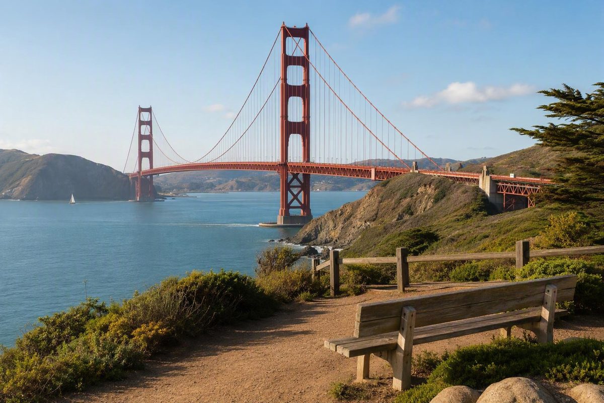
“Golden Gate Bridge Park View” is not the formal name of an attraction identified in the available official or travel sources. It is more useful to treat the phrase as a search for a bridge view from parkland, a beach, or an outdoor overlook.
For the simplest park-style stop on the San Francisco side, choose Battery East Vista. For a close, elevated panorama from the Marin Headlands, choose Battery Spencer. The right option depends on the photograph you want, your tolerance for stairs or slopes, and whether crossing the bridge is worth the added parking and access uncertainty.
The quick answer: Battery East Vista or Battery Spencer
Battery East Vista is the strongest literal match for a Golden Gate Bridge park view. It combines a panorama of the bridge, San Francisco Bay, and the Marin Headlands with plaza seating, trail connections, bike parking, paid parking, accessible spaces, and access to an accessible segment of the California Coastal Trail.
It is also easier to fit into a San Francisco day. You can approach from the Golden Gate Bridge Welcome Center, stop at the vista without committing to a long hike, and continue through the Presidio only if time, energy, and conditions support it.
Battery Spencer is the stronger choice when the photograph matters more than simplicity. From its elevated position north of the bridge, the bridge dominates the foreground while San Francisco and the bay sit beyond it. The principal overlook has defined accessibility features, but the trail continuing past it becomes substantially steeper.
The practical trade-off is straightforward:
- Easiest park-style stop: Battery East Vista
- Close elevated panorama: Battery Spencer
- Bridge towers framed by trees: Golden Gate Overlook
- Beach foreground: Baker Beach
- Bridge structure and history: Fort Point
- Bridge with skyline context: Hawk Hill
Neither Battery East Vista nor Battery Spencer is universally “best.” Scenic rankings are personal. Battery East fits more naturally with San Francisco transit and Presidio walks.
Viewpoint comparison table
The first table compares the view and walking effort. The second separates accessibility, arrival, and the main limitation so that an accessible overlook is not confused with an accessible adjoining beach, historic building, or trail.
| Viewpoint | Side of bridge | Visual perspective | Walking effort |
|---|---|---|---|
| Battery East Vista | San Francisco | Broad bridge, bay, and Marin Headlands panorama | Low-effort plaza visit; longer walks are optional |
| Battery Spencer | Marin | Close, elevated bridge-dominant panorama | Short approach to the principal overlook; much steeper beyond it |
| Golden Gate Overlook | San Francisco | Bridge towers framed between cypress trees | Short overlook visit; verify the complete route |
| Crissy Field | San Francisco | Lower waterfront view across the bay | Flatter along the waterfront; the connection toward the bridge can involve steep stairs |
| Fort Point | San Francisco | Underside, masonry, and structural scale | Waterfront approach; museum entry is required for the rooftop viewpoint |
| Baker Beach | San Francisco | Sand, ocean, bridge, and Marin Headlands | Beach terrain with parking access |
| Marshall’s Beach | San Francisco | Close beach-and-rock foreground | High effort: steep trail and many stairs |
| Hawk Hill | Marin | More distant bridge with the San Francisco skyline behind it | Some walking; verify the route before visiting |
| Lands End | San Francisco | Distant coastal landscape across the bay entrance | Varies by the selected trail or overlook |
| Viewpoint | Known access features | Transit or parking | Main limitation |
|---|---|---|---|
| Battery East Vista | Seating, accessible parking spaces, bike parking, and an accessible Coastal Trail segment | Paid lot beside the vista; transit approaches require a walk, according to the official Battery East Vista listing | Accessible features do not establish that every connecting route is step-free |
| Battery Spencer | Two accessible stalls, accessible-surface overlook, accessible benches, and accessible vault toilet | Marin-side road access; consult current maps and alerts | The onward trail becomes sharply steeper, as detailed by the National Park Service |
| Golden Gate Overlook | Verify current route accessibility and facilities | Presidio trails or nearby parking; verify before visiting | Limited space or facilities may affect the visit |
| Crissy Field | Flatter waterfront options are available; verify the specific route | Parking and transit options vary | Going from the waterfront toward the bridge can add steep stairs |
| Fort Point | Verify current building and rooftop access | Waterfront approach; verify current arrival details | Rooftop view requires museum entry |
| Baker Beach | Parking approach followed by beach terrain | Two parking lots are identified in the supplied travel source | Lots may fill on sunny weekends |
| Marshall’s Beach | No low-effort approach established | Reached by trail and stairs | Steep descent followed by the return climb |
| Hawk Hill | Verify current accessibility and route details | Requires Marin Headlands access | Exposed conditions and change-sensitive road access |
| Lands End | Depends on the chosen overlook or trail | Verify current parking and route details | Not the choice for a close bridge portrait |
The terrain, museum-entry, beach-access, and parking observations for Crissy Field, Fort Point, Baker Beach, and Marshall’s Beach are described in a local comparison of Golden Gate Bridge viewpoints. Conditions and operational details can change, so use those distinctions to narrow your choice rather than as a substitute for same-day checks.
Accessibility should be assessed from the actual arrival point to the view. A marked accessible parking space does not establish that every connected trail, beach, stairway, or historic structure is accessible.
Battery East Vista: the easiest park-style choice
Battery East Vista works when you want a recognizable Golden Gate Bridge view without turning the stop into a major hike. The scene includes the bridge, San Francisco Bay, and the Marin Headlands, while the amphitheater-style plaza provides seating and room to pause.
The vista connects with the California Coastal Trail and Bay Area Ridge Trail. Those connections make it easy to extend the outing, but they do not require you to create a long loop. A cleaner plan is to reach the vista first and treat every additional trail segment as optional.
The site also has bike parking, paid parking, accessible parking spaces, and access to an identified accessible segment of the California Coastal Trail. Those are features of the vista area; they should not be interpreted as proof that every approach from transit or every adjoining trail is step-free.
For a car-free arrival, Muni Route 28 stops at the Golden Gate Bridge Welcome Center. The Presidio estimates the walk from there to Battery East Vista at approximately 15 minutes. Golden Gate Transit also serves the toll plaza area. Muni Route 43 and Presidio Go serve the Presidio Transit Center, from which the Presidio estimates a longer walk of approximately 31 minutes. These are planning estimates rather than guaranteed journey times; the routes and current service should be confirmed before departure on the Presidio’s Battery East Vista page.
A simple one-direction visit looks like this:
- Arrive near the Golden Gate Bridge Welcome Center.
- Walk to Battery East Vista.
- Use the plaza seating and take in the panorama.
- Continue to one nearby Presidio overlook only if the terrain, visibility, and your energy make that worthwhile.
- Finish near a practical transit pickup point instead of forcing a loop.
This structure keeps the bridge view as the purpose of the outing. If you want more walking, add it after reaching the vista rather than making the view depend on finishing a longer route.
Battery East Vista is especially useful when people in the same group have different walking tolerances. Before doing so, check the selected trail rather than assuming its surface and grade match those of the overlook.
Battery Spencer: the close Marin panorama
Battery Spencer is north of the Golden Gate Bridge in the Marin Headlands. Its value is the elevated angle: the bridge fills the foreground, with the bay and San Francisco beyond it. The composition feels markedly different from Battery East Vista’s lower, park-like panorama or Baker Beach’s ocean-side foreground.
The National Park Service identifies two accessible parking stalls, accessible-surface access to the principal overlook, accessible benches, and an accessible vault toilet. It also warns that the trail beyond the overlook increases drastically in slope. Treat the overlook and the continuing trail as two separate route decisions, not as one uniformly accessible experience. The exact features and limitations are set out in the NPS Marin Headlands accessibility guidance.
Battery Spencer is worth crossing the bridge for when you specifically want a close, elevated photograph. It is less compelling as a default choice for someone who wants to remain within San Francisco, avoid uncertain parking, or keep the day easy to shorten.
Some travel writers describe Battery Spencer as their favorite or “best” bridge viewpoint. That is an attributed preference, not an objective ranking. The same dramatic position that improves the photograph also makes the outing more dependent on Marin access, exposed conditions, and the ability to adapt if the road or parking situation is difficult.
Before leaving, consult current National Park Service maps and alerts rather than relying on an older route description. Parking near the viewpoint is limited according to supplied travel accounts, and congestion or road controls can complicate access. Avoid building a tightly timed itinerary around arriving at one particular parking area.
Keep a San Francisco-side backup such as Battery East Vista or Golden Gate Overlook. Fog can obscure all or part of the bridge, while exposed headland locations can be windy and chilly. A backup near your original side of the bridge is more useful than a second option requiring another long crossing or detour.
Choose the view, not just the viewpoint name
The most efficient choice starts with the composition and outing you want.
For towers framed by trees, choose Golden Gate Overlook. Its signature view places the bridge towers between two cypress trees. It works best as a focused photo stop or as the one additional overlook paired with Battery East Vista.
For a flatter waterfront outing, choose Crissy Field. The waterfront provides a lower view across the water without requiring you to begin on a headland trail. Keep the waterfront and the climb toward the bridge separate in your planning: part of the connection from the Crissy Field area toward the bridge involves a steep stairway.
For engineering and history, choose Fort Point. The fort stands below the bridge’s southern end, placing the underside and structural scale of the bridge at the center of the view. Museum entry is required to reach the rooftop viewpoint, so verify current access before making the roof your main objective.
For sand and ocean in the foreground, choose Baker Beach. It offers an ocean-side view of the bridge and Marin Headlands, with parking access that avoids the steep trail used to reach Marshall’s Beach. Beach terrain still applies after arrival, and the lots may fill on sunny weekends.
For a closer beach-and-rock composition, choose Marshall’s Beach. Reaching it requires a steep trail with many stairs. That makes it a deliberate beach hike rather than a quick roadside viewpoint, and the descent must be followed by a return climb.
Marshall’s Beach and the bridge-adjacent end of Baker Beach are described in the supplied travel sources as clothing-optional areas. Visitors choosing those locations should expect a different setting from a formal plaza or roadside overlook.
For bridge-and-skyline context, choose Hawk Hill. The bridge appears farther away, with San Francisco behind it. Verify current routes and accessibility before departure rather than assuming that conditions match another Marin overlook.
For a distant coastal landscape, choose Lands End. Here the bridge becomes one element in a broader view across the entrance to San Francisco Bay. Choose it for coastal scenery rather than a close bridge portrait.
Do not turn the visit into a nine-viewpoint checklist. On the San Francisco side, pair Battery East Vista with one nearby Presidio overlook. In Marin, pair Battery Spencer with one other overlook only if the roads, weather, parking situation, and your energy make that easy.
Plan around parking, terrain, fog, and temporary closures
Do not build the day around finding a parking space beside the bridge. The bridge operator describes parking at the southeast and northeast visitor areas as extremely limited and encourages transit, walking, cycling, rideshare, or a tour bus instead.
An official 2026 alert lists bridge parking-lot closures on weekends and holidays from May 25 through October 12, 2026. That dated restriction may supersede normal operating information. Under the regular listing, the southeast visitor lot has 37 spaces, charges $5 per hour, and has a three-hour maximum, but those details do not guarantee that the lot will be open or have space. Check the current bridge parking notices before relying on it.
Use this same-day checklist:
- Check National Park Service alerts and current maps.
- Review bridge parking notices and road restrictions.
- Confirm transit schedules and the return route.
- Check construction and accessibility updates.
- Review current wind and visibility conditions.
- Bring a layer for exposed waterfront and headland locations.
- Decide in advance which nearby viewpoint will be your backup.
If you drive, follow the visitor guidance to remove valuables and leave no belongings visible in the vehicle; this is precautionary advice, not an assurance that any parking area is secure. The same recommendation appears in the local Golden Gate Bridge viewpoint guide.
Match the terrain to the route, not merely to the destination name. Crissy Field can support a flatter waterfront outing, but continuing toward the bridge may add steep stairs. Marshall’s Beach requires a steep descent and return climb. At Battery Spencer, the principal overlook has specific accessible features, but the onward trail is substantially steeper.
The most reliable plan is to choose one primary viewpoint based on transportation, terrain, and the view you want, then keep one nearby backup. Choose Battery East Vista for the simplest park-style San Francisco visit or Battery Spencer for a close elevated Marin panorama. If fog, parking, wind, road access, or terrain makes the original choice impractical, change viewpoints rather than adding a long cross-city or cross-bridge detour.
Can pedestrians walk onto the Golden Gate Bridge from the viewpoints?
Yes, but not directly from every overlook. On the San Francisco side, the Welcome Center and southeast visitor area provide the clearest approach to the pedestrian entrance. Pedestrians use the bridge’s east, or bay-side, sidewalk. Check current access before making the bridge walk the endpoint of a viewpoint visit.
What hours is the Golden Gate Bridge sidewalk open to pedestrians?
Published pedestrian hours are 5:00 a.m. to 6:30 p.m. during Pacific Standard Time and 5:00 a.m. to 9:00 p.m. during Pacific Daylight Time. Construction, lane configurations, high winds, holidays, and special events can change access, and some construction-related weeknight closures may begin earlier. Confirm the official pedestrian schedule and current alerts on the day of the visit.
Can I fly a drone near the Golden Gate Bridge?
No. The bridge operator prohibits drones over or near the Golden Gate Bridge and other bridge district property. Drones are also prohibited on the surrounding National Park Service land immediately north and south of the bridge under the official bridge sidewalk and drone rules.