
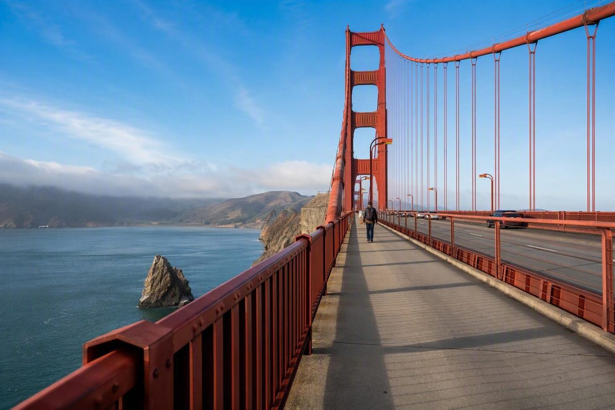
Golden Gate Bridge walk at a glance
Yes, pedestrians can walk across the Golden Gate Bridge without paying an admission fee. A listing that describes the broader bridge site as open continuously does not mean the pedestrian sidewalk is available 24 hours a day. A commercial visitor guide also describes the crossing as free while advising visitors to verify the current sidewalk schedule before arriving (Bay City Bike visitor guide).
Because the supplied visitor page does not publish a date-specific pedestrian schedule or live closure details, do not rely on fixed hours copied into an old itinerary. Check the Golden Gate Bridge District’s current pedestrian information and any operational notices available on the day of your visit.
The bridge is commonly published as approximately 1.7 miles long. Treat that as the overall bridge length, not a precise measurement between the points where pedestrians enter and leave the sidewalk. For practical planning, allow approximately 45–60 minutes for a leisurely one-way crossing. An unhurried round trip with photographs may require approximately 90 minutes to two hours, depending on pace, wind, crowds, visibility, mobility, and the number of stops (Golden Gate National Parks Conservancy).
For a straightforward first visit:
- Begin at the southeast Visitor Plaza on the San Francisco side.
- Use the restroom and obtain food or water before entering the span.
- Dress for an exposed, windy walk rather than for conditions downtown.
- Decide in advance whether you will walk partway, cross once, or make a round trip.
- Attempt a one-way crossing only after confirming how you will leave the Marin-side bridge area.
- Shorten the route if weather, comfort, or timing deteriorates.
Visitor services are concentrated near the ends of the bridge. Do not begin expecting the span to function like a waterfront promenade with convenient indoor breaks, food counters, or frequent facilities. It is an exposed urban bridge crossing beside moving traffic.
If you have less than an hour, uncertain conditions, limited walking capacity, or no confirmed Marin-side return, walk partway and return to the plaza. You do not need to cross the entire bridge to experience it.
Choose the right walk: partial, one way, or round trip
The best Golden Gate Bridge walk depends less on ambition than on return logistics. A partial walk, one-way crossing, and round trip all put you on the span, but they create different demands on your time, energy, and transportation.
| Walk | Approximate commitment | Best suited to | Main complication |
|---|---|---|---|
| Partial out-and-back toward the first tower | Flexible; often under an hour | Short visits, uncertain conditions, limited stamina, or no Marin return plan | You do not reach the north end |
| Complete one-way crossing | About 45–60 minutes, plus onward transportation | Visitors with a verified pickup or current transit plan | You finish in the Marin-side bridge area and still need to leave it |
| Complete round trip | About 90 minutes to two hours with stops | Visitors who want a full crossing without arranging a separate return | It doubles the exposed walking |
These are planning ranges, not promises. The published one-way estimate is approximately 45–60 minutes; a round trip should allow roughly twice the walking plus time for photographs and pauses.
Partial out-and-back
For many first-time visitors, a partial out-and-back is the simplest choice. Start at the southeast plaza, walk toward the first tower, and turn around whenever time, weather, or comfort suggests it. The tower is a useful visual objective, but it is not necessary to treat it as an officially designated turnaround point.
This format preserves flexibility. If the wind becomes unpleasant, fog obscures the views, or someone tires sooner than expected, you can reverse course without creating a transportation problem. You also finish near the same visitor services and San Francisco-side connections you used at the start.
A short walk can be more satisfying than rushing a complete crossing and then spending the next hour trying to arrange a return. Even 20 or 30 minutes on the bridge can provide the sensation of walking onto the span without committing the group to its full length.
Complete one-way crossing
A one-way crossing provides the full bridge experience without requiring you to walk the span twice. It is appropriate only when you have confirmed the next step before leaving San Francisco.
Crossing the bridge does not place you in Sausalito. You finish in the Marin-side bridge area. From there, your departure depends on a prearranged pickup, a currently operating transit connection, or a longer onward route.
The available evidence does not establish a dependable current bus route, stop, or departure schedule from the north end. That means the responsible planning workflow is:
- Identify the exact north-end stop or pickup point you intend to use.
- Check the responsible operator’s current schedule and service alerts.
- Confirm that service operates on your visit date and near your expected arrival time.
- Save the stop location before entering the bridge.
- Establish a backup, such as a confirmed pickup or the willingness and time to walk back.
Do not treat an old route number in a travel guide as a current return plan. If you cannot complete those checks, choose a partial walk or round trip instead.
Direction is a preference rather than a universal rule. Walking north from the southeast plaza works naturally if you plan to continue into Marin. Some visitors prefer walking south because the San Francisco skyline stays ahead, but that requires reaching the Marin side before the walk begins.
Complete round trip
For visitors who want to cross the entire bridge, a round trip is often the simplest option when mobility, weather, and available time permit. You return to the southeast plaza, where visitor information, restrooms, food, parking, and San Francisco-side transportation are concentrated.
The tradeoff is physical rather than logistical: you double the distance and exposure. A manageable breeze on the outbound walk may become tiring after a long photograph stop or a change in conditions. Budget toward the upper end of the range if you want an unhurried visit.
A round trip is not automatically the best choice for everyone. Visitors with limited stamina, mobility requirements, or a confirmed pickup may prefer another format. The advantage is simply that it removes the uncertainty of finding transportation from the north end.
Continuing to Sausalito
Walking to Sausalito is a separate outing, not a short add-on to the bridge crossing. As one third-party route example, AllTrails lists a point-to-point route of approximately 3.9 miles, about 396 feet of elevation gain, and an estimated 1.5–2 hours. Those figures apply to that platform’s defined route rather than to every possible itinerary, and user reports mention roadside stretches and interactions with cyclists or joggers (AllTrails bridge-to-Sausalito route).
Do not assume that the entire extension has the same sidewalk character or accessibility as the bridge. Added elevation, navigation, roadside exposure, and mixed or uncertain surfaces can change the experience substantially.
A ferry may be one return option from Sausalito, but service should never be assumed. Verify the current operator, departure point, schedule, ticket arrangements, and backup transportation before leaving San Francisco.
The most useful decision rule is simple: if the Marin-side return is uncertain, choose a partial walk or round trip.
Where to start and how to reach the bridge
The southeast Visitor Plaza on the San Francisco side is the most practical starting area for many first-time visitors. It is not the only pedestrian entrance, but it places visitor services near the beginning of the walk and makes both a partial route and a round trip straightforward.
Around the plaza are the Welcome Center, exhibits, visitor assistance, Presidio maps, bike parking, paid parking, food and drinks, restrooms in a separate nearby building, and several overlooks. That concentration matters because it is easier to correct a forgotten restroom stop or missing layer before entering the span.
The Welcome Center is generally listed as open from 9 a.m. to 6 p.m. daily except Thanksgiving and Christmas, subject to current verification. Its published accessibility features include street-level access, automatic doors, accessible parking, and accessible restrooms. The same official park guide identifies Muni Route 28 at the Golden Gate Bridge Tunnel/Merchant Road stop and explains that Presidio GO requires an additional walk of approximately 1.6 miles, or about half an hour, from the Presidio Transit Center (Presidio Welcome Center guide).
Arriving by transit
Muni Route 28 is a documented San Francisco connection to the bridge area. Check the current SFMTA schedule, service alerts, and stop details before departure rather than assuming a timetable remains unchanged.
Presidio GO is not described as door-to-door bridge service. The published approach involves riding to the Presidio Transit Center and then walking west for approximately 1.6 miles. That may suit visitors who want an additional park walk, but it should count toward the day’s total distance and time.
For visitors with a timed itinerary, transit is generally more dependable than building the entire day around obtaining a specific parking space. It also allows more flexibility if you change the walk format—although a one-way crossing still requires a separately verified Marin-side exit plan.
Driving and parking
Paid parking exists near the Welcome Center and at other nearby locations, but availability is limited. Rules, fees, time limits, construction effects, and lot access can vary. A map that identifies a parking area does not guarantee that it will be open or have space when you arrive.
If you drive, allow enough time to follow current signs and use a legal alternative rather than circling the plaza until the walking window disappears. Do not schedule a tight reservation or transportation connection on the assumption that immediate plaza parking will be available.
Parking farther away may also add hills or approach trails. Count that walking toward the group’s total effort, particularly if you plan a complete round trip.
Pre-departure checklist
Before traveling to the bridge, confirm four things:
- Pedestrian access: Check the current sidewalk schedule and any operational notices available for the day.
- Transportation: Review current transit service or parking conditions and, for a one-way walk, the exact Marin-side departure plan.
- Weather: Inspect conditions near the bridge rather than relying only on a downtown forecast.
- Walk format: Decide whether you are doing a partial walk, one-way crossing, or round trip.
A one-way crossing without a verified exit is not simpler than a round trip. It merely delays the difficult decision until you are farther from your starting point.
What the crossing is actually like
The Golden Gate Bridge walk is an exposed urban crossing, not a quiet nature trail. You walk beside moving traffic while wind, fog, open water, crowds, and limited shade influence how the span feels.
When visibility permits, the bridge can provide views toward the Pacific Ocean, Marin Headlands, San Francisco Bay, and the city. Those views change as you move across the span, but fog can obscure them. Do not organize the entire outing around reproducing a particular photograph.
Wind may affect temperature, conversation, balance, pace, and how long you want to remain exposed. Fog can arrive or clear, changing visibility and perceived temperature.
Visitors seeking a calmer waterfront experience may prefer Crissy Field or Fort Point. Both keep the bridge in view without requiring the whole outing to take place beside bridge traffic.
Depending on current sidewalk operations, pedestrians may encounter cyclists or other faster path users. Sidewalk assignments and sharing arrangements can change, so follow the signs and instructions posted during your visit rather than relying on a permanent rule from a forum or old guide.
The reviewed visitor information identifies food, restrooms, and assistance near the bridge ends rather than as regular services along the span. Use the facilities before entering and carry what you expect to need.
When to turn around
There is no need to pursue one official turnaround point. Reverse course while the return still fits your available time, comfort, daylight, and the pedestrian operating window.
Reassess at visible landmarks:
- Is everyone still comfortable and warm enough?
- Has the wind increased?
- Is visibility improving or deteriorating?
- Will the return fit the available walking time?
- Does the group have enough energy for the same distance back?
Your outbound pace may not predict the return. Photographs, crowds, headwinds, and fatigue can slow the second half.
For a partial walk, the first tower is an intuitive objective because it creates a sense of entering the bridge without committing to the north end. Turning around earlier is equally valid if conditions are poor.
For a one-way walk, continue only while the confirmed Marin-side plan remains workable. If a pickup or transit problem emerges early, reverse course while doing so is still convenient.
Weather, clothing, and sidewalk etiquette
Dress for the bridge rather than for the neighborhood where your day begins. Conditions on the span can be cold, windy, or foggy even when central San Francisco feels comfortable.
Wear layers that are easy to add or remove. A wind-resistant outer layer is generally more useful than relying only on one bulky garment. Comfortable walking shoes matter even for a partial crossing because the surface is hard and visitors often spend substantial time standing for views.
Bring:
- Water
- Sun protection
- A wind-resistant layer
- Comfortable walking shoes
- Essential medication or personal supplies
- A light bag that leaves your hands free
Do not base your plan on finding convenient food, restrooms, or indoor shelter after you have entered the span.
There is no universally best time to walk. A commercial visitor guide suggests that mornings may have fewer people and that later periods can sometimes provide clearer views, but neither outcome is dependable. Choose a time that fits the current pedestrian schedule and the rest of your itinerary rather than chasing a weather guarantee.
Share the sidewalk predictably
The most useful etiquette is to be visible and predictable:
- Keep to the side indicated by current signs.
- Stay aware of faster users approaching from behind.
- Avoid sudden sideways movements when taking photographs.
- Move out of the main circulation line before stopping.
- Keep children close and explain that the sidewalk is a working shared route, not an open plaza.
- Follow posted notices and directions from bridge personnel.
Do not rely on unofficial reports for current rules governing pets, scooters, skates, e-bikes, powered mobility devices, or sidewalk allocation. Those policies can be detailed and change with operations. Verify any rule that directly affects your visit through current Bridge District guidance.
Know when to change the plan
A full crossing is optional. Switch to a shorter or different outing when:
- Wind makes steady walking uncomfortable.
- Fog removes the views that motivated the crossing.
- Pedestrian access is restricted or unavailable.
- Someone in the group is uneasy with traffic noise or exposure.
- The available time no longer supports the return.
- The transportation plan becomes uncertain.
The southeast plaza, nearby overlooks, Fort Point, and Crissy Field all provide ways to experience the bridge area without forcing a complete crossing.
Accessibility and lower-effort planning
Trail guidance describes the bridge crossing as possible on foot, by bicycle, or by wheelchair. Keep that claim narrow: it does not establish that every approach, viewpoint, connected trail, or Sausalito extension is accessible. The route guidance also advises visitors to prepare for wind and fog (Bay Area Ridge Trail bridge segment).
Around the southeast Welcome Center, published amenities include accessible parking and restrooms. The center has street-level access and automatic doors, while the restrooms are in a separate building across the parking area and include accessible stalls.
The available evidence does not establish every detail that may matter to an individual visitor, including bridge-specific grades, cross-slopes, curb transitions, resting intervals, benches, or current rules for every powered mobility device. Visitors with precise mobility or assistance requirements should verify current access and support information before traveling.
A partial out-and-back is often the simplest lower-effort strategy because the visitor controls the turnaround and returns to the same services. It also avoids depending on an unfamiliar north-end transfer.
Optional extensions require separate evaluation. Nearby approaches and viewpoint routes may introduce stairs, steep paths, older structures, mixed surfaces, or roadside walking. The full route toward Sausalito should not be described as universally wheelchair- or stroller-friendly merely because a route platform applies a broad accessibility label.
Crissy Field as a generally level alternative
Crissy Field Promenade is a separate waterfront walk rather than a bridge crossing. The National Park Service lists it as 2.3 miles with approximately 10 feet of elevation gain. Published surfaces include compacted natural material, boardwalk, asphalt, and a wooden pedestrian bridge, while accessible parking and restrooms are identified near its main access areas (National Park Service Crissy Field Promenade guide).
This route provides views of the bay, bridge, and marsh habitat while allowing more flexibility than a complete crossing. It may suit visitors who want open scenery without committing to sustained traffic noise and bridge exposure.
“Generally level” is more precise than “easy.” Distance, surfaces, wind, crowds, and individual mobility requirements still matter.
The same caution applies to children. No outdoor route is universally appropriate for every child. Guardians should assess walking tolerance, wind, noise, exposure, crowds, and the child’s ability to follow directions around faster path users. A short out-and-back may work better than making a complete crossing the required goal.
Restrooms, food, exhibits, and worthwhile additions
Plan facilities in route order, beginning on the San Francisco side.
At the southeast plaza, the Welcome Center provides visitor assistance, maps, merchandise, and exhibits. Restrooms are in a separate nearby building rather than inside the center. Food and drinks are available around the Round House area, while Battery East, Golden Gate Overlook, and Pacific Overlook provide nearby viewing options.
The Welcome Center’s exhibits address the bridge’s history, science, engineering, and construction. It also displays the original 12-foot stainless-steel test tower used in 1933, according to the Bridge District’s description of the visitor facilities (Golden Gate Bridge visitor information).
Use the plaza facilities before stepping onto the sidewalk. Five minutes spent there is easier than discovering well onto the bridge that someone needs a restroom or food break.
Both ends of the bridge connect with the Golden Gate National Recreation Area, so longer trail extensions are possible. That does not make every connected route a natural continuation for a first-time visitor. Additional trails can add elevation, stairs, exposed terrain, route-finding, or transportation complications.
Nearby additions that stay manageable
Battery East can be combined with the plaza for another bridge angle without committing to a major second outing.
Golden Gate Overlook and Pacific Overlook can work as brief viewing stops. Trying to reach every overlook in one visit adds more walking and parking complexity than many visitors expect.
Fort Point sits beneath the southern end of the bridge. It provides a different perspective on the structure but remains a separate destination with its own access and operating considerations.
Crissy Field is also a separate walk. Its waterfront setting provides views of the bridge, bay, and marsh, with restrooms and picnic facilities around the broader area.
Be careful when comparing Crissy Field distances. The National Park Service defines a 2.3-mile Crissy Field Promenade, while the Presidio describes a broader 4.3-mile Golden Gate Promenade/Bay Trail outing connecting the Marina Gate area with Fort Point. These are different route definitions and should not be combined (Presidio Golden Gate Promenade guide).
For most visitors, one or two nearby additions are enough. A manageable half-day might include the Welcome Center, a partial bridge walk, and one overlook. Another could combine Crissy Field with Fort Point and skip the crossing.
Trying to collect every overlook, both bridge directions, Fort Point, Crissy Field, and Sausalito in one continuous outing creates unnecessary fatigue and transportation complexity.
For another route-planning approach, San Francisco Know publishes a self-guided Golden Gate waterfront walk connecting the Marina, Crissy Field, and the bridge. Use it as an itinerary option, not as evidence of current bridge operations, accessibility, or sidewalk conditions.
Guided walk and bad-weather alternatives
San Francisco City Guides offers selected guided Golden Gate Bridge walks focused on subjects including history, engineering, geology, weather, the maritime setting, and construction.
The listed tour lasts approximately 1.5–2 hours, begins at the Strauss statue in the San Francisco-side visitor plaza, includes stairs, and ends at the South Tower. It is not described as a complete guided bridge crossing. Check the current calendar, availability, registration process, group requirements, and any cost or donation details before attending (San Francisco City Guides tour page).
A guided walk can suit visitors who value interpretation more than distance. It provides context without creating a Marin-side return problem. Because the route includes stairs, visitors with mobility requirements should verify accommodations rather than assuming that the accessibility of the bridge sidewalk extends to the organized tour.
If the full crossing no longer makes sense
Use this fallback menu:
- Explore the Welcome Center and plaza exhibits. This keeps you near assistance, food, and restrooms.
- Visit one nearby overlook. Battery East, Golden Gate Overlook, or Pacific Overlook can provide a short outdoor component.
- Walk part of Crissy Field Promenade. Turn around when weather, time, or energy suggests.
- Continue toward Fort Point. Do so only if current access, time, and mobility permit.
- Walk briefly onto the bridge and return. A short partial crossing still provides the experience of standing on the span.
Crissy Field and Fort Point may better suit visitors who prioritize waterfront movement and bridge views over walking beside traffic. They are different ways to experience the landscape, not consolation prizes.
The practical hierarchy is simple: preserve the day first. Shorten the crossing before creating a return problem. Change to a waterfront route before wind makes the outing miserable. Choose a nearby overlook before using limited time to force a low-visibility crossing.
A dependable plan is to verify pedestrian access and weather, begin at the southeast plaza, use the facilities before entering the span, and select a partial walk, one-way crossing, or round trip according to a confirmed return. If wind, fog, time, mobility, or transportation makes the complete crossing impractical, switch to Crissy Field, Fort Point, or a nearby overlook. That is a successful visit, not a failed bridge walk.
Golden Gate Bridge walk FAQ
Is it free to walk across the Golden Gate Bridge?
Yes. Pedestrians can walk across the Golden Gate Bridge without paying an admission fee, subject to sidewalk operating hours and temporary restrictions (A Modern Mother walking guide).
Transportation, parking, food, and separately organized activities may create their own costs. Check the relevant operator or provider before relying on a particular service.
How long does the Golden Gate Bridge walk take?
The Parks Conservancy’s published planning estimate is approximately 45–60 minutes for a one-way crossing. For an unhurried round trip, allow approximately 90 minutes to two hours, including time for photographs and pauses.
A partial out-and-back can fit a shorter window because you control the turnaround. Actual time depends on pace, wind, crowds, visibility, mobility, and the number of stops.
Is the Golden Gate Bridge pedestrian sidewalk open 24 hours?
No. The broader bridge site may be described as open continuously, but pedestrian access follows designated sidewalk hours. Commercial visitor guidance likewise identifies limited pedestrian hours and advises checking the official schedule because operating times can vary.
Verify the current pedestrian schedule and any operational notices on the day of your visit rather than relying on fixed hours from an older guide.
Can I walk across the bridge and continue directly to Sausalito?
You can continue toward Sausalito, but the north end of the bridge is not Sausalito. Reaching town requires a separate, longer route with additional elevation, navigation, and roadside exposure.
Treat the extension as its own outing. Confirm the walking route and return transportation—including any ferry, bus, or pickup—before leaving San Francisco.
What is a quieter alternative if I do not want to cross the bridge?
Crissy Field Promenade is the clearest alternative. It is a generally level waterfront route with views of the bridge, San Francisco Bay, and marsh habitat, plus nearby restrooms and picnic facilities.
Fort Point is another option for seeing the bridge from below, subject to current access and operating conditions. You can also combine a short Crissy Field walk with one nearby overlook, preserving the scenery without spending a full crossing beside bridge traffic.